Hiking WV: Blackwater Falls
After dinner on Friday, we wanted an easy hike to stretch our legs out, so we did Lindy Point.


After dinner on Friday, we wanted an easy hike to stretch our legs out, so we did Lindy Point.
Michael has use-or-lose-leave, so we spent a long weekend in the Canaan area doing lots of hiking.
In the morning we hiked two trails: Blackwater River trail and the Middle Ridge trail. I have pictures from the one and data from the other.
Location: Canaan Valley State Park
Trail: Middle Ridge Trail
Distance: 2.3 miles (loop)
Elevation: 3331-3558 (483 feet gain)
Temperature: 66-74
The Middle Ridge Trail doesn’t have many scenic vistas, but it does go through several different kinds of areas, and goes by a bog–it’s dry right now, so I didn’t find anything picturesque about the bog, but on the plus side, our feet stayed dry.
I do love the Blackwater River Trail


Here is the elevation graph for the Middle Ridge Trail.

The weather recently has been all over the place, but Saturday was beautiful, so we took the opportunity to go to Cacapon. (I was also hoping that there might be blooming flowers at Berkeley Springs.)
For all the rain we’ve had, the trails we hiked were weirdly dry–because they were so steep.
Location: Cacapon State Park
Trails: Ziler, Ziler Loop Trails
Distance: 5.5 miles
Elevation: 961-2273 feet (1800 feet gain)
Temperature: 58-67 F
0.6 mile of Ziler trail was 22.6% grade
Entire Ziler trail was 1.3 miles @ 17.6% grade with 1242 feet ascent

For all the elevation gain, there aren’t any decent scenic overlooks or views–the woods are thick and there what rock outcroppings there are don’t go above the treeline.
That doesn’t mean there isn’t a view, it just means there isn’t a photographable view.

At some point we’re going take the trail to Prospect Rock. But this trip we apparently wanted to torture ourselves with the Ziler trail.
This may well have been our last hike in snow of the season, so I was glad we were able to enjoy it–and that it was such a beautiful day.
I love the Cranberry Wilderness and am glad we got to hike it in the snow.
Location: Cranberry Wilderness
Trail: Charles Creek, Cowpasture Trails
Distance: 1.9 miles
Elevation: 3422-3564 feet
Temperature: 31 F
There used to be a prison in this area–a prison that didn’t bother with walls and barbed wire, since it was so far away from civilization that there was nowhere for escaped prisoners to go.
Although this prison was open during the Korean war (conscientious objectors were typically sent here) there are very few signs of civilization left: some spots of asphalt, the occasional chimney, and some stairs.


Charles Creek


The Falls of Hills Creek is one of the places where there is a very small window of time if you want light for taking pictures.
We managed to nail that window Saturday.
Lower Falls

Hills Creek


Middle Falls


Our original plan was the get to Canaan Thursday night and spend Friday and the weekend hiking, but when the forecast changed to rain on Saturday and overcast all Friday, we shifted things a bit so I could take pictures Thursday afternoon, and then Friday would be hiking.
We got very lucky, because instead of overcast, the weather was partially cloudy, and our hike at Dolly Sods ended up being absolutely stunning.
Location: Dolly Sods
Trails: Rocky Ridge, Blackbird Knob, Harman Trails
Distance: 4.2 miles
Elevation: 3746-4190 feet (684 ft)
Temperature: 30-41F
We’ve had a lot of odd weather this winter. For the second time this month, we had rain immediately followed by freezing temperatures and snow. When the rain fell on ground that was already freezing, it meant a lot of ice.
This was the trail we took up to Dolly Sods. It was a little more exciting than I generally prefer.
Luckily, that was the worst portion of anything we hiked, and the view was well-worth the care we had to take reaching the ridge.

Until temperatures warmed up to the mid 30s, all the trees were covered with snow and frost, and we walked through an amazing winter wonderland.


We hiked down to the Left Branch of Red Creek and then turned around. It wasn’t one of our longest hike, but stepping into the occasional drift made the hike a little more work than usual.
It once again reminded me how very lucky I am to both live in such an amazing place, and be able to get out and enjoy it.

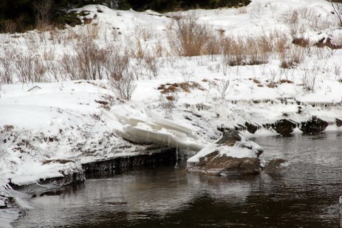
Of course we hiked the Blackwater Trail at Canaan Valley, because it’s one of my favorite trails, and since it’s short and easy, there’s never a reason not to hike it.

I’ve been trying for as long as I’ve been hiking this trail to get a picture I liked of these stones (they are in several places). Finally, with the light coming through the winter trees and the snow lightening everything, I finally got a couple pictures I liked.

Ice sandwich!


It had warmed up by the time we made it to New River Gorge, but there was still snow, and it was still beautiful.
We hadn’t been to endless wall in the winter before, so I was surprised to see 1) how close we actually were to the ground and 2) the shape of the underlying mountains.

With the leaf fall, you can see across the river to the Kaymoor Miners Trail and old Kaymoor Mine site.
If you zoom in on this picture, you can more clearly see the 821 steps down to the railroad tracks.

Here is the bottom of the site and you can see the decayed buildings and ghosts of the railroad tracks.

The trail itself is a relatively easy and has an amazing payoff.

We wandered off trail a bit to explore the creek.


We were originally heading to Cranberry Glades when I realized how beautiful the morning was, and that Babcock State Park would most likely be beautiful, so we stayed on 19 and were well-rewarded.
We didn’t hike much, just walked around finding the places I thought would be most beautiful.


Since we’d had a cold snap after the rains, and since temps were supposed to start rising, we took Friday to travel to Blackwater Falls in hopes that the falls were frozen.
It hadn’t bee cold enough to freeze the falls completely, but there was still a fair amount of ice.

Why yes, I did ignore the “Closed” sign and went down the stairs.
For this view? It was worth it. (Plus, I was very careful.)

Pretty!

We also went down to Elakala Falls.

Let me be clear, the scramble down is never especially easy, but in the winter, especially after a lot of rain and then a snap freeze, the path is treacherous.

We wore Yaktrax, because I know very well how clumsy I am.
But it was well worth it.

Because it was already warming up, water was starting to trickle down the icicles.

We also went to Canaan Valley SP.

I mentioned that earlier we’d had rain and then a quick freeze earlier. I hadn’t quite thought about how that would affect this boggy, marshy area.
What happened is that the low areas flooded, and then froze. So any low-lying ground ended up covered in ice.

Normally we’ll walk out to the end of this bit of land, but the path was solid ice–and slippery. So we just looked (it wasn’t worth the view to pull out and put on the Yaktrax). It was pretty amazing.
If you look closely at this picture, you’ll see that a layer of ice formed on the grass, several inches above the ground.

It was a wonderful day, and I’m glad we were able to get away to enjoy it.

We ended 2017 with a hike and Coopers Rock, and began 2018 in the same way.
It was cold, but the days were beautiful so we had wonderful hikes!
Date: 2017-12-31
Location: Coopers Rock State Forest
Trails: Headwaters, Roadside Trails
Distance: 3.3 miles
Elevation: 1874-2412 feet
Temperature: 11-14 F


Date: 2018-01-01
Location: Coopers Rock State Forest
Trails: Hemlock Trail
Distance: 2.3 miles
Elevation: 1620-1866 feet
Temperature: 8-10 F


As I’ve mentioned before, this is one of my favorite hikes. It’s very short, so it’s good for small kids, but you walk through different habitats and it’s just gorgeous.

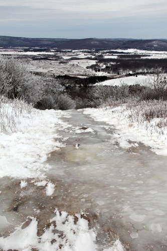
This is the first time the Blackwater river has been frozen when we’ve hiked here.

This is the point at which someone went through the ice–and that someone was NOT me.

Picture taking had been curtailed after someone (NOT ME) got their lower leg wet. But I still got a couple shots I really liked.
Friday was overcast and snowing, which was beautiful in its own way, but not very photogenic.
By Saturday afternoon, skies were clear and the sun was out. It was beautiful.


It was a beautiful hike on a beautiful day with lovely company.
We went hiking on the Wednesday before Thanksgiving, Black Friday, that Sunday, and Sunday the 3rd. I forgot my camera for the first two hikes, and only pulled it out once when I did remember it.
The thing about the woods in fall is that it’s beautiful, but I can’t say it’s especially photogenic.
At Coopers Rock, unless you’re hiking Ravens Rock, pretty much every trail is down hill on your way out, and then uphill on your way out.
Here you’re at the bottom of the Rhododendron trail. Mont Chateau is off to your right. Henry Clay Iron Furnace, Clay Furnace Trail, Clay Run Trail, and Advanced Ski Trail are all behind you. Several of those trails have trails branching off of them, so you can make a variety of loops.
But it’s all going to be uphill from here, unless you go down to the lake. Then it’s even more uphill upon your return, unless you have someone to drive you back from the lake up the mountain to where you left your car.

Here is one of the two bridges by Henry Clay Iron furnace. This is the area where multiple streams meet to then run down to the lake. Going up most of the trails you can see the streams turn from running water to run off areas that are flowing only after a rain or when the snow melts.
But down here, there is always water.

And then leaves piled up in the stream.

I can spend, literally, hours wandering around these streams, building rock towers, knocking down leaf dams and moving sticks that are blocking the stream.
My excuse is that I want to keep the streams and run-off areas from backing up onto the trails, which makes them a muddy mess that is exacerbated by all the mountain bikes, but truly, I just like playing in the water.
Powered by WordPress


As an Amazon Associate I earn from qualifying purchases.
So if you click through on one of the book links I might get a half penny or so and eventually be able to buy a new book to read!
