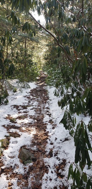
Random (but not really)

Sunday, October 20, 2019

Traveling WV: Fall Rivers

We stopped at several state parks on Friday, two of which have some lovely river views.

We were a tad bit late for good light at Carnifex Ferry, but none-the-less it’s a lovely view of the Gauley River.

2019-10-18_Carnifex_Ferry_195

There was a bit of color, but nowhere near as much as there should have been for mid-October.

2019-10-18_Carnifex_Ferry_207

We stopped by Hawk’s Nest earlier in the day, and saw a different portion of the New River.

2019-10-18_Hawks_Nest_057

2019-10-18_Hawks_Nest_062

We also went down into the New River Gorge. They were getting ready for Bridge Day, and there wasn’t very much color, even if it was a lovely view.

Written by Michelle at 8:00 am    

Comments (0)  Permalink

Categories: Photos,State Park / Forest,West Virginia  

Saturday, October 19, 2019

Traveling WV: New Places

I taught in Charleston on Friday, so we decided to take the super scenic route home, and ended up on a road we hadn’t taken before, and got to visit two new neat places!

Kanawha Falls

2019-10-18_Kanawha_Fals_003

2019-10-18_Kanawha_Fals_027

Cathedral Falls

2019-10-18_Cathedral_Falls_040

There are people in this picture, for perspective.

2019-10-18_Cathedral_Falls_047

Written by Michelle at 6:16 pm    

Comments (0)  Permalink

Categories: Photos,West Virginia  

Monday, October 14, 2019

Hiking WV: Canaan and Blackwater Falls (Again)

Saturday was supposed to rain, plus my aunt was coming in, so we did our hiking on Friday, which turned out to be a perfect choice.

Checked what the leaf color was supposed to be, so headed back down to the Canaan / Blackwater Falls area.

Canaan Valley State Park: Blackwater River Trail

2019-10-11_Canaan_Valley_SP_106

2019-10-11_Canaan_Valley_SP_113

2019-10-11_Canaan_Valley_SP_090

Blackwater Falls

2019-10-11_Blackwater_Falls_032

2019-10-11_Blackwater_Falls_041

2019-10-11_Blackwater_Falls_074

Table Rock

2019-10-11_Canaan_Table_Rock_130

2019-10-11_Canaan_Table_Rock_163

2019-10-11_Canaan_Table_Rock_138

2019-10-11_Canaan_Table_Rock_158

Written by Michelle at 7:13 pm    

Comments (0)  Permalink

Categories: Hiking,National Park / Forest,Photos,State Park / Forest,West Virginia  

Sunday, October 6, 2019

Sunday Flower Pr0n: I Love Autumn Edition

You’ll have to forgive me that these are not actually flower pictures, but rather pictures that happen to contain colorful leaves.

A burden I’m sure, but you’ll have to live with it.

We went to Canaan Valley State Park, the Blackwater Canyon, and Blackwater Falls State Park. We didn’t do any serious hiking, because I wanted to see what fall color there was. (Not a whole lot, but there was some.)

Blackwater River Rail Trail

2019-10-05_Blackwater_Rail_Trail_060

Douglas Falls

2019-10-05_Blackwater_Rail_Trail_033

Pendleton Creek

2019-10-05_Blackwater_Falls_022

2019-10-05_Blackwater_Falls_009

Blackwater River Trail (Canaan)

2019-10-05_Canaan_Valley_SP_019

2019-10-05_Canaan_Valley_SP_031

Written by Michelle at 9:55 am    

Comments (2)  Permalink

Categories: Photos,West Virginia  

Sunday, September 29, 2019

Sunday Flower Pr0n

Not a lot of flowers to be found at Spruce Knob and Seneca Rocks, but these were pretty.

2019-09-28_Seneca_Rocks_002

2019-09-28_Seneca_Rocks_012

2019-09-28_Seneca_Rocks_010

Written by Michelle at 4:05 pm    

Comments (0)  Permalink

Categories: Flowers,Photos  

Tuesday, September 24, 2019

Hiking WV: Seneca Creek Backcountry

On the 7th of September we headed south towards Spruce Knob and decided to hike at Seneca Creek Backcountry, which I love but don’t hike enough.

I really have no sense of self-preservation. I was startled by a falling leaf and by a butterfly, but noticed the noise of a rattlesnake only when Michael started freaking out behind me. Seriously, he’s hyperventilating and I’m all, “What? What?”

But leaves? Those will totally startle me.

Location: Seneca Creek Backcountry
Trail: Horton Trail
Distance: 5.2 miles
Elevation: 2955-4154 feet (1229 feet gain)

Aside from the hike being straight up the ridge, it was a lovely day and I really do need to hike there more often.

2019-09-07_Seneca_Creek_016

Written by Michelle at 8:00 am    

Comments (0)  Permalink

Categories: Hiking,National Park / Forest,Photos,West Virginia  

Monday, September 23, 2019

Hiking WV: Cranberry Wilderness / Cranberry Glades

Location: Cranberry Wilderness
Trail: Blue Knob Trail
Distance: 2.0 miles
Elevation: 3742-4161 feet (423 feet gain)

Oh look! If I stand on this log and peer carefully, I can see the Highland Scenic Highway!

2019-09-21_Cranberry_005

If you remember way back into the spring, beavers had flooded the boardwalk over the winter. Last visit the walk was dry, but still not repaired.

Now, they’ve fixed this section of boardwalk (but others are problematic) but the pond is almost gone.

2019-09-21_Cranberry_055

2019-09-21_Cranberry_057

2019-09-21_Cranberry_056

Also, please enjoy these views:

2019-09-21_Cranberry_029

2019-09-21_Cranberry_065

2019-09-21_Cranberry_086

Written by Michelle at 8:00 am    

Comments (0)  Permalink

Categories: Hiking,National Park / Forest,Photos,West Virginia  

Sunday, September 22, 2019

Sunday Flower Pr0n: Cranberry Glades

Late September is when the earliest leaves change color in areas like Cranberry Glades and Dolly Sods and Canaan Valley. Since I love Cranberry Glades best that’s where we went.

Not much in the way of leaf color, but a beautiful day nevertheless.

2019-09-21_Cranberry_049

2019-09-21_Cranberry_072

2019-09-21_Cranberry_068

2019-09-21_Cranberry_042

2019-09-21_Cranberry_078

2019-09-21_Cranberry_081

Written by Michelle at 6:59 pm    

Comments (0)  Permalink

Categories: Flowers,National Park / Forest,Photos,West Virginia  

Sunday, September 1, 2019

Jackson’s Mill

Went south yesterday for the Jackson’s Mill Jubilee. As noted in previous years, there are fewer crafters each time we visit. But lots of live music–and I saw quite a few younger musicians alongside the old bearded dudes.

Since we were wasting time waiting for the start of the game so we could go home, I spent lots of time wandering around the mill.

I love that place So. Much.

2019-08-31_Jacksons_Mill_001

2019-08-31_Jacksons_Mill_019

2019-08-31_Jacksons_Mill_009

2019-08-31_Jacksons_Mill_025

2019-08-31_Jacksons_Mill_006

2019-08-31_Jacksons_Mill_004

Written by Michelle at 4:37 pm    

Comments (0)  Permalink

Categories: Photos,State Park / Forest,West Virginia  

Sunday, August 25, 2019

Hiking WV: Blackwater Canyon

As I mentioned previously, the monitor on my Asus laptop died, so although we did take a lovely hike a couple weeks ago at the Cranberry Wilderness, I did not manage to write about it or post any pictures.

This weekend Michael was still recovering from the start of school (couple weeks of 10-12 hours days. Ugh.) so we didn’t want to go far, so the Blackwater Falls / Canaan Valley area it was.

I remembered that it’d been a couple years since I’d taken any pictures of Douglas Falls, so that’s where we headed, and then continued out the defunct rail trail (it’s private property, so the trail is not maintained for 5 1/2 miles, but it was perfectly fine to hike).

The fun part was our argument as to whether Michael has seen Pace Point or not. I’m pretty sure he didn’t. We did definitely see Lindy Point though. (We’ve argued for years as to whether you can see Lindy Point from Pase Point. I say definitely not.)

Location: Blackwater Canyon Rail Trail
Distance: 6.2 miles (partial, out and back)
Elevation: 2755-2918 feet (410 feet gain)

Definitely Lindy Point, as seen from across the river.

2019-08-24_Blackwater_Canyon_073

This is what Michael says is Pase Point. I say NOPE.

2019-08-24_Blackwater_Canyon_084

The old coke ovens along the trail are AMAZING.

2019-08-24_Blackwater_Canyon_114

It’s actually a lovely trail.

2019-08-24_Blackwater_Canyon_071

2019-08-24_Blackwater_Canyon_091

Douglas Falls

2019-08-24_Blackwater_Canyon_045

Lovely!

Written by Michelle at 8:49 pm    

Comments (0)  Permalink

Categories: Hiking,National Park / Forest,Photos,West Virginia  

Sunday Flower Pr0n: Blackwater Canyon Edition

The monitor on my Asus laptop died, and although I did use my desktop computer for processing images, if I’m going to spend lots of time on the computer, I’d rather do so upstairs on a laptop, so Michael and I can be in the same room ignoring each other.

Saturday we hiked the rail trail along the Blackwater Canyon, and we did manage to see wildflowers (even if there were (sadly) no snacks along the trail).

Not *quite* UF, but definitely not high fantasy, I do recommend Steven Brust’s Vlad Taltos series. I’ve fallen off keeping up with the series, because there were a LOT of delays for about a decade, but I need to pick it back up.

2019-08-24_Blackwater_Canyon_092

2019-08-24_Blackwater_Canyon_099

2019-08-24_Blackwater_Canyon_019

2019-08-24_Blackwater_Canyon_002

2019-08-24_Blackwater_Canyon_098

Written by Michelle at 8:24 pm    

Comments (0)  Permalink

Categories: Flowers,Photos  

Sunday, June 30, 2019

Sunday Flower Pr0n: Cranberry Glades

Orchids were in bloom at Cranberry Glades.

2019-06-29_Cranberry_049

2019-06-29_Cranberry_048

2019-06-29_Cranberry_068

2019-06-29_Cranberry_036

Also in bloom:

2019-06-29_Cranberry_061

2019-06-29_Cranberry_080

2019-06-29_Cranberry_078

2019-06-29_Cranberry_090

It was a LOVELY day to be in the Cranberry Wilderness and walk the Cranberry Glades boardwalk.

Written by Michelle at 7:14 pm    

Comments (0)  Permalink

Categories: Flowers,Photos  

Monday, June 24, 2019

Hiking WV: Blackwater Canyon

I’ve been sickly for about two weeks, getting over some kind of cold/respiratory thingy. So yesterday we wanted to hike somewhere close, and take a hike that wasn’t too strenuous.

Apparently, we have a strange definition of strenuous.

We ended up going to Thomas/Davis because it’s a short-ish drive, and there are tons of places to hike. We were considering the Canaan Wilderness, but I looked through the hiking books on the way down, and decided we should try some more hiking in the Blackwater Canyon (across the gorge from Blackwater Falls State Park).

Location: Blackwater Canyon
Trails: Allegheny and Limerock Trails
Distance: 8.2 miles
Elevation: 2863-3118 feet (590 feet rise)

It seems that for us, 8.2 miles turned out to be taking it easy. We did have a much slower pace than we normally hike (30 min mile vs 20 min mile) and the majority of the hike was on a railroad grade trail, so it was a slower elevation rise. Essentially, we parked, and hikeed out until we decided we were ready to turn around.

The temperatures were perfect for hiking, the weather was lovely, and aside from one dirt biker on the RR grade trail, we didn’t see anyone else while we were out.

So: a good day.

2019-06-22_Blackwater_Canyon_004

2019-06-22_Blackwater_Canyon_021

2019-06-22_Blackwater_Canyon_020

2019-06-22_Blackwater_Canyon_007

Written by Michelle at 6:00 am    

Comments (0)  Permalink

Categories: Hiking,National Park / Forest,Photos,West Virginia  

Sunday, June 23, 2019

WV Roads

I’ve talked about WV roads before, and I truly don’t think most people really get it.

US Route 50 stretches from the east coast to the west coast. It was constructed in the mid 1920s. So it’s been around for awhile and used to be a major thoroughfare.

West of I79, US 50 in WV is relatively straight, and for the most part a divided highway. East of I79 it is two lanes, 7-11% grades, and hairpin turns. The GPS often loses signal along the more winding stretches and has us either inside the mountain or floating above the gorge. (“Damnit! You’re off-roading again!”)

When I talk about reasons why WV has trouble getting jobs because of lack of infrastructure, US 50 East of I79 immediately comes to mind. No one in the right mind would bring production into an area where you cannot drive large trucks.

So in an effort to try and explain WV roads, here is a small section of US 50, taken over approximately 5 minutes, up to and then down one of my least favorite stretches of US 50. (This is NOT the section with the switch backs.) I named the pictures with the date and time, and all should have GPS coordinates.

Ready? Here we go!

18-55-00. Coming up to the top of the mountain, there are multiple signs warning trucks about the hill. “Trucks must stop 1/4 mile”

18-55-16. “Trucks must stop 1000 FT”

18-55-27. “ALL TRUCKS”

18-55-39. “Trucks. 20 MPH Curve Bottom of Grade.”

Oh yeah, this section of downhill ends in a sharp curve.

18-56-03. Here we go!

18-56-20. “Rough Road”

Because of course the road is subsiding.

18-56-55

18-57-12.

18-57-15. “9%”

18-57-27.

18-58-46. “30 MPH”

18-59-12.

18-59-23. “9%”

18-59-45.

19-00-13. “9%. 1/2 MILE”

19-00-39. “20 MPH”

That’s the final turn and now you’re down in the valley.

Five minutes. 9% grade. And it you mess up you’re smashed into the side of the mountain or plunging into the gorge.

These is a US route, not a county road. THIS is why we can’t get jobs in WV. Not because the people are unwilling to work, but because businesses can’t GET to the areas where jobs are needed.

Written by Michelle at 6:19 pm    

Comments (0)  Permalink

Categories: Photos,Politics,West Virginia  
« Previous PageNext Page »

Powered by WordPress