Random (but not really)

Tuesday, May 28, 2019

Hiking WV: Seneca Rocks

Sunday was our annual hike up Seneca Rocks in memory of my cousin Ben. Ben died in 2012, and every year since then we’ve hiked up Seneca Rocks on his birthday. And since we’re doing it in memory of Ben, we have to go all the way to the top without stopping.

I was chatting with Tania the night before, and she asked if I was still mad at Ben. I said much less than I had been.

I changed my mind about 2/3rds of the way up.

I’m not as mad at him as I used to be (once I catch my breath, that is) but it’s still hard for me to accept. And it most likely always will be.

Although there was rain throughout the day, it held off for our hike, as well as while we were enjoying the view.

Location: Seneca Rocks
Distance: 3.6 miles
Elevation: 1546-2407 feet (919)
Temperature: 75 F

Hike up:
Distance: 1.2 miles
Elevation: 1578 – 2319 feet (740); 11.6% grade
Time: 32 minutes

2019-05-26_Seneca_Rocks_067

2019-05-26_Seneca_Rocks_016

2019-05-26_Seneca_Rocks_024

2019-05-26_Seneca_Rocks_026

Written by Michelle at 6:00 am    

Comments (0)  Permalink

Categories: Family,Hiking,National Park / Forest,Photos,West Virginia  

Monday, May 20, 2019

Hiking WV: Canaan Valley

We’d hoped to spend some time hiking in the southern part of the state after I finished teaching in Charleston, but thunderstorms nixed that plan, so we came home, and had a day trip to Canaan.

This is one of the places we go frequently, because it’s relatively close to Morgantown, and there are SO MANY places to hike.

Location: Canaan Wilderness
Trail: Lindy Run, Plantation, Fire Trails
Distance: 4.0 miles
Elevation: 3459-3652 feet (397 feet gain)
Temperature: 82 F

Wet trail.

2019-05-18_Canaan_Wilderness_001

Wet crossing.

2019-05-18_Canaan_Wilderness_012

Dry trail.

2019-05-18_Canaan_Wilderness_011

Gorgeous creek.

2019-05-18_Canaan_Wilderness_013

Written by Michelle at 7:44 pm    

Comments (0)  Permalink

Categories: Hiking,National Park / Forest,Photos,West Virginia  

Sunday, May 19, 2019

Sunday Flower Pr0n: Canaan Valley Edition

Our original plans for the weekend were thrown into disarray, so we went to Canaan Valley on Saturday for a little hiking, and to see what spring wildflowers were out.

Answer: lots and lots.

2019-05-18_Canaan_Valley_009

2019-05-18_Canaan_Wilderness_005

2019-05-18_Canaan_Valley_021

2019-05-18_Canaan_Valley_007

2019-05-18_Canaan_Valley_025

Tuesday, April 30, 2019

Hiking WV: Cranberry Wilderness

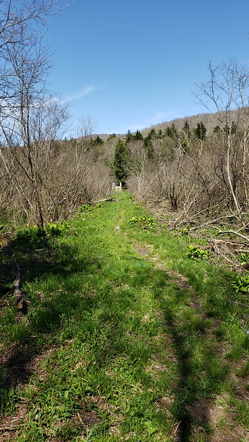
The boardwalk is lovely, but .8 miles and flat is not a hike, so we decided to go out a bit on the Cow Pasture Trail, in the hopes there would be wildflowers.

There are LOTS of wildflowers.

We hiked parts of the other end of the trail, but hadn’t walked any of the western part of the trail.

It was gorgeous.

There are so many trails I want to hike in the Cranberry Wilderness, but most of them are long and would require an overnight stay–which we can do, but haven’t been able to do. (Because rain, work, reasons.)

Location: Cranberry Wilderness
Trail: Cow Pasture Trail
Distance: 4.9 miles
Elevation: 3347-3462 feet (364 feet rise)
Temperature: 59 F

2019-04-27_Cranberry_101

2019-04-27_Cranberry_102

2019-04-27_Cranberry_086

2019-04-27_Cranberry_084

Written by Michelle at 6:00 am    

Comments (0)  Permalink

Categories: Hiking,National Park / Forest,Photos,West Virginia  

Monday, April 29, 2019

Hiking WV: Cranberry Glades

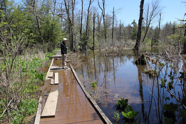
If you haven’t been (and really, why haven’t you?), Cranberry Glades is an amazing area. It’s an area of bogs with plants typically found much farther to the north (like Canada).

It’s a very brief walk, and usually handicapped accessible, however, a section of boardwalk currently needs repaired, due to beaver activity.

It was a gorgeous day, and there were quite a few people on the boardwalk (by quite a few, I mean there there were about six cars in the parking lot).

If you have the chance, head there now, while the flowers are in bloom.

Location: Cranberry Glades
Trail: Cranberry Glades Boardwalk
Distance: 0.8 miles
Elevation: 3620-3659 feet (46 feet rise)
Temperature: 55 F

2019-04-27_Cranberry_062

2019-04-27_Cranberry_050

2019-04-27_Cranberry_047

2019-04-27_Cranberry_057

Written by Michelle at 6:00 am    

Comments (0)  Permalink

Categories: Hiking,National Park / Forest,Photos,West Virginia  

Wednesday, April 17, 2019

Hiking WV: Blackwater Falls State Park

Not finding a lot of flowers at Canaan, we went to Blackwater Falls, in hopes some drier trails might have more wildflowers.

They didn’t, but it was a gorgeous day for a hike, so it’s still a win.

Location: Blackwater Falls
Trails: Elakala and Shay Trace Trails
Distance: 1.2 miles
Elevation: 3082-3228 feet (212 feet rise)
Temperature: 68F

Trails: Dobbins House and Pace Point Trails
Distance: 2.9 miles
Elevation: 2993-3160 feet (274 feet gain)
Temperature: 72F

We went out to Pace Point, in the hopes we’d see lots of flowers. Not many flowers, but still a lovely hike. Then we spent a bit of time at the top of Pendleton run.

2019-04-13_Blackwater_Falls_053

2019-04-13_Blackwater_Falls_061

And since we were on Elakala Trail, we of course scrambled down.

2019-04-13_Blackwater_Falls_016

2019-04-13_Blackwater_Falls_039

It was such a lovely day!

Written by Michelle at 6:00 am    

Comments (0)  Permalink

Categories: Hiking,Photos,State Park / Forest,West Virginia  

Tuesday, April 16, 2019

Hiking WV: Canaan Valley State Park

One of the reason I wanted to go hiking was because I finally replaced my GPS.

I’ve had the Oregon 550t since 2013, and it remains a workhorse. However, it’s accuracy was getting problematic. If we’re hiking a loop, our starting and ending elevations should be approximately the same.

The last loop we hiked our starting elevation was 1592 and the ending elevation was 1637. And our peak elevation was 1774 feet going out, and 1850 feet coming back. Those elevations should have been the same, not 45-76 feet different.

So after a lot of back and forth and a month of thinking about it I got a Garmin Oregon 700.

There have been a lot of improvements in the past six years, and although I liked the Orgeon 550t, I LOVE the 700.

The point of all this is what I wanted to use the new GPS.

So our first use was one of my favorite trails.

Location: Canaan Valley SP
Trail: Blackwater River Trail
Distance: 0.8 miles
Elevation: 3202-3261 (78 feet gain)

2019-04-13_Canaan_002

2019-04-13_Canaan_019

GPS was perfect, and the hike was lovely; Win win!

Written by Michelle at 8:00 am    

Comments (0)  Permalink

Categories: Hiking,Photos,State Park / Forest,West Virginia  

Sunday, March 17, 2019

Hiking WV: Babcock State Park & NRG

Finally! A Saturday without rain and mud!

After scanning the regional weather, we headed south towardsNew River Gorge, but as always happens, I said, “Oh! Can we stop by Babcock?”

Since there weren’t that many people, and since the day was beautiful, we decided to take the Lake View Trail, which we hadn’t hiked before.

It was gorgeous.

Location: Babcock State Park
Trail: Lake View Trail
Distance: 1.7 miles
Elevation: 2404-2596 ft

2019-03-16_Babcock_025

2019-03-16_Babcock_021

Of course I took a picture of the grist mill.

2019-03-16_Babcock_015

We went onto New River Gorge for a hike there, and decided to take the Bridge View Trail, which… was a view of the underside of the bridge. Which is fine, but not what I was thinking (I was thinking a view like Long Point, but from the other side.)

Location: New River Gorge
Trail: Bridge View Trail
Distance: 1.6 miles
Elevation: 1587-1852 feet (519 feet climb)

It was steep (with switchbacks) and rocky, with steps made from the area stones.

2019-03-16_Babcock_028

Not one of my favorite hikes, but I was outside in the woods, so that made it better than many other things.

Written by Michelle at 9:50 am    

Comments (0)  Permalink

Categories: Hiking,National Park / Forest,Photos,State Park / Forest,West Virginia  

Sunday, October 14, 2018

Hiking WV: Canaan Valley

There was also a dearth of color at Canaan Valley (and Blackwater Falls).

Still pretty though.

2018-10-12_Canaan_Valley_051

2018-10-12_Canaan_Valley_055

2018-10-12_Canaan_Valley_053

Written by Michelle at 7:16 pm    

Comments (0)  Permalink

Categories: Hiking,Photos,State Park / Forest,West Virginia  

Hiking WV: Seneca Rocks

Since the weather was forecast to be nice, and Michael had the day off, Saturday we decided to head down to Seneca Rocks, in hopes of catch some fall color.

The weather was lovely, but there was a distinct lack of fall color.

2018-10-12_Seneca_Rocks_049

Location: Seneca Rocks
Trail: Seneca Rocks Trail
Distance: 3.7 miles
Elevation: 1573-2520 feet (1003 ft rise)

Hike Up
1.2 miles
1611-2446 feet
33 minutes

It doesn’t look like there’s that much water going over the bridge!

2018-10-12_Seneca_Rocks_002

Guess who had wet feet for this hike?

One of the reasons I wanted to make this hike on a Friday and not Saturday is that it tends to be really busy on Saturdays, and I selfishly prefer solitude when at the top of the rocks.

2018-10-12_Seneca_Rocks_022

2018-10-12_Seneca_Rocks_007

2018-10-12_Seneca_Rocks_025

Written by Michelle at 7:10 pm    

Comments (0)  Permalink

Categories: Hiking,National Park / Forest,Photos,West Virginia  

Monday, October 1, 2018

Hiking WV: Cranberry Wilderness

After a week of rain, Saturday was clear, so we headed to the Cranberry Wilderness, which has become one of my favorite places, since it is far less visited that most other spots in WV.

We hiked two shorter trails, wanting the views as much as the hiking.

Location: Cranberry Wilderness
Trail: Red Spruce Trail
Distance: 2.3 miles
Elevation: 4386-4722 feet (420 ft gain)

Is that… a bear track? (Click through to Flickr for a comparison picture.)

2018-09-29_Cranberry_Wilderness_001

The trail at the top of the mountain was unbelievably gorgeous. Look at that! So beautiful!

2018-09-29_Cranberry_Wilderness_005

Because Red Spruce Knob is the highest peak in the area, there was a fire tower here at one point. That tower is long gone, and most of the overlook is overgrown.

2018-09-29_Cranberry_Wilderness_007

Still worth the hike.

Trail: High Rocks Trail
Distance: 3.2 miles
Elevation: 4312-4507 feet (471 ft gain)

The trail to High Rocks was possibly one of the easiest we’ve ever hiked in the Mon Nat’l Forest. We kept waiting for it to get super muddy or terribly rocky or ridiculously steep; Nope. It was a very easy hike.

2018-09-29_Cranberry_Wilderness_009

It was a ridiculously easy hike, for the view at the end.

Written by Michelle at 6:00 am    

Comments (0)  Permalink

Categories: Hiking,National Park / Forest,Photos,West Virginia  

Wednesday, September 26, 2018

Hiking WV: Dolly Sods

Since we had a long weekend and didn’t have to drive, we wanted to do a long hike on Friday.

There are so many places to choose from in the Canaan Valley area, but we eventually settled on Dolly Sods, and a trail we’d wanted to hike before, in the hopes that it being a Friday morning we wouldn’t see so many people.

We saw… fewer people than we would on a Saturday, but we still saw more people than I particularly wanted to on a hike in the wilderness.

Location: Dolly Sods Wilderness
Trails: Rocky Ridge, Blackbird Knob Trails
Distance: 7.6 miles
Elevation: 3757-4184 feet (1137 feet gain)

2018-09-21_Dolly_Sods_038

2018-09-21_Dolly_Sods_054

Blackbird Knob Trail

2018-09-21_Dolly_Sods_057

2018-09-21_Dolly_Sods_049

Yes, the trail really is that rocky and wet and muddy. So many people hike Dolly Sods that everything is very worn and never gets a chance to recover.

Despite the wilderness being busier than one would expect, views like this make the trip worth it.

2018-09-21_Dolly_Sods_013

Written by Michelle at 6:00 am    

Comments (0)  Permalink

Categories: Hiking,National Park / Forest,Photos,West Virginia  

Tuesday, September 25, 2018

Hiking WV: Blackwater Falls State Park

We hadn’t been out to Pace Point in awhile, so we decided that’d be our easier hike after a long hike at Dolly Sods.

Location: Blackwater Falls State Park
Trails: Pendleton Trace, Dobbin House and Pase Point Trails
Distance: 2.9 miles
Elevation: 3009-3170 feet

2018-09-21_Blackwater_Falls_010

Location: Blackwater Falls State Park
Trails: Lindy Point Trail, Canaan Loop Road
Distance: 1.4 miles
Elevation: 3139-3216 feet

The next day we decided to head out to Lindy Point (and the stream along Canaan Loop Road)

2018-09-22_Blackwater_Falls_058

Here’s the stream that crosses Canaan Loop Road. I haven’t seen that much water there before.

2018-09-22_Blackwater_Falls_068

We ended up having a multi-day debate as to whether you can see Lindy Point from Pase Point (and vice versa)

I say you can’t, Michael says you can.

Written by Michelle at 6:00 am    

Comments (0)  Permalink

Categories: Hiking,Photos,State Park / Forest,West Virginia  

Monday, September 24, 2018

Hiking WV: Canaan Wildlife Refuge

We did two hikes at the Canaan Wildlife Refuge. A hike along the Beale Trail that’d we’d done before, but chose because it was easy, because it was raining.

The first hike was new to us, partway up Cabin Mountain. We considered hiking to the top of the trail, but were afraid it’d be dark on the way down, and I’d trip over everything.

Location: Canaan Valley Wildlife Refuge
Trails: Middle Ridge and Sand Run Trails
Distance: 3.6 miles
Elevation: 3246-3571 feet (597 ft gain)

2018-09-22_Canaan_Valley_WR_009

Is that… a bridge?

2018-09-22_Canaan_Valley_WR_003

Yes! A completely useless bridge!

2018-09-22_Canaan_Valley_WR_002

Michael: They need to mow this bridge.

2018-09-22_Canaan_Valley_WR_012

All kidding aside, it was a nice, if rather steep hike, and I definitely want to hike up to the top of the Cabin Mountain Trial to see the view.

Location: Canaan Wildlife Refuge
Trail: Beall Trails
Distance: ~3 miles (I forgot to turn on the GPS until half a mile in)
Elevation: 3151-3375 feet

It’s raining. Where shall we hike? A bog of course!

At the Bog Overlook

2018-09-23_Canaan_Valley_WR_002

2018-09-23_Canaan_Valley_WR_009

Written by Michelle at 6:53 pm    

Comments (0)  Permalink

Categories: Hiking,National Park / Forest,Photos,West Virginia  
« Previous PageNext Page »

Powered by WordPress