Random (but not really)

Sunday, July 16, 2017

Hiking WV: Cranberry Wilderness

We’ve wanted to do a long hike in the Cranberry Wilderness for quite awhile, however, a 2+ hour drive, then a long hike, then another 2+ hour drive was… unappealing.

So we’ve spent the past couple months gather things we’d need for an overnight trip where there aren’t hotels, Michael rented a tent from the Rec Center, and we were off!

Location: Cranberry Wilderness
Trails: North-South and Lick Branch trails and FR 76
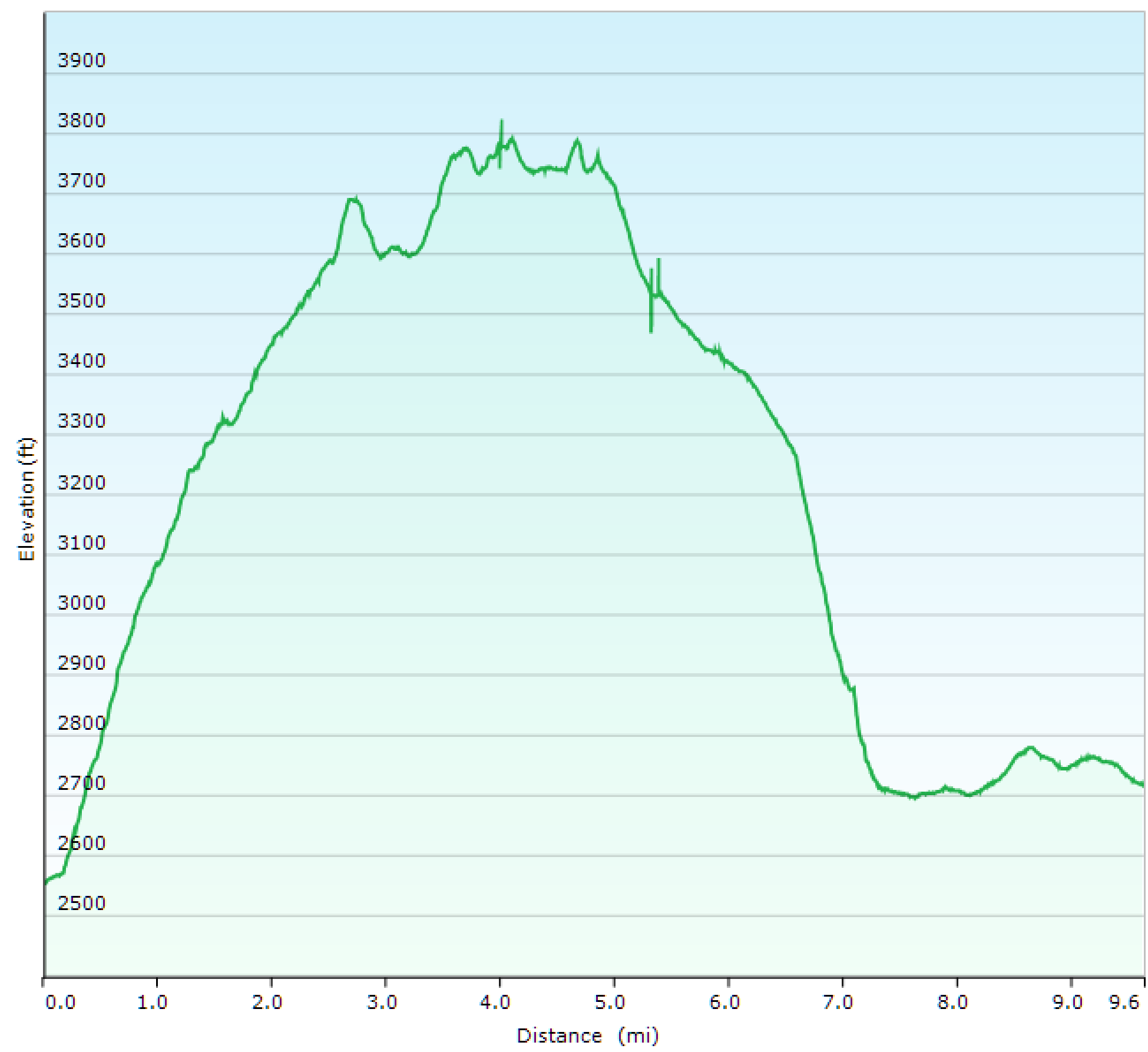
Distance: 9.6 miles
Elevation: 2552-3795 feet (1618 feet elevation gain)

One of the books I have recommend this hike in the opposite direction.

No.

The direction we went–North-South trail followed by Lick Creek Trail and then taking the road back is the way you want to do this look.

First, the North South trail is fine, but it’s steep from the campsite to the ridgeline–about a 9% grade. And although it’s pleasant enough, it’s not the most rewarding view.

Although we did amuse ourselves.

20170715_Cranberry_Wilderness_006

That sign? It’s warning you that no motorized vehicles are allowed on the Wilderness.

20170715_Cranberry_Wilderness_005

There is another sign, in a wide view showing you the the surrounding trail.

There is no way you could GET a motorized vehicle to where these signs were, unless it was a hovercraft, and even then it’d be chancy. There were endless fallen trees, lots of going through narrow passages etc.

So, I giggled every time I saw those signs someone was forced to place in an area already inaccessible to motorized vehicles.

Also found a newly placed marker!

20170715_Cranberry_Wilderness_009

And several swarms of butterflies.

20170715_Cranberry_Wilderness_015

But, it wasn’t anything spectacular. No views down into the various valleys, etc.

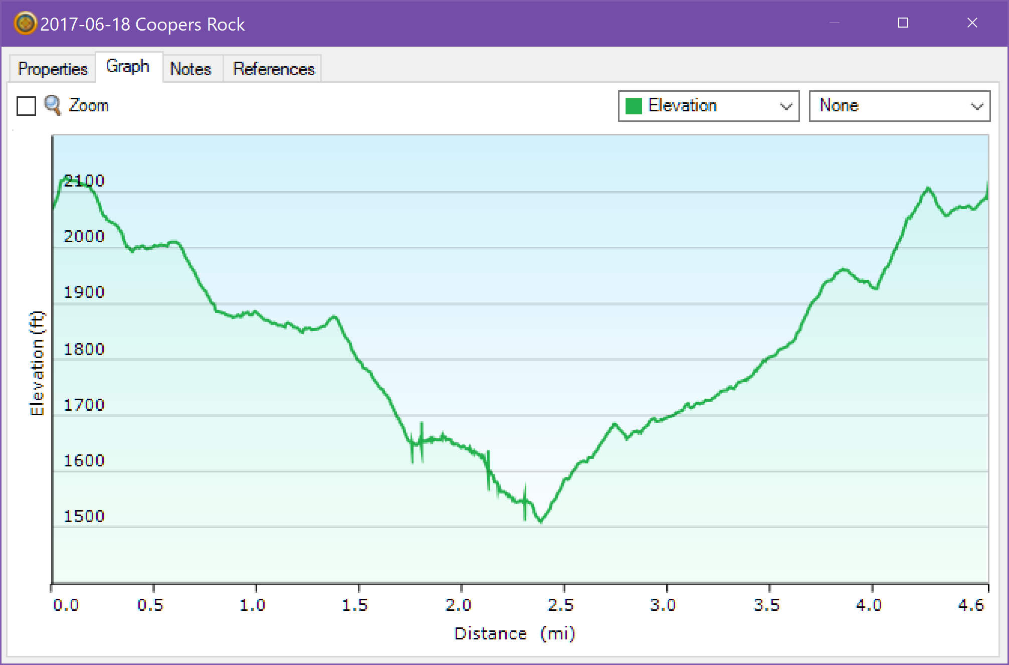
Here is the start of Lick Creek at the top of the Lick Creek trail. Now things are starting to get pretty!

20170715_Cranberry_Wilderness_019

And this is the end of the trail–pretty much visible from the forest road (and by road, I mean Fire Trail type road, closed to cars but accessible in an emergency).

20170715_Cranberry_Wilderness_027

Why put the prettiest thing at the start of the strenuous part of the hike? What is your reward for finishing? A 9% grade? Bah humbug.

Additionally, since the last couple miles were on the forest road, that meant we were able to stretch our legs and walk out the kinks from the ascent and descent. Nice! And the road is along the river! So pretty!

So my recommendation is start this loop from the gate. Unless you’re a masochist, in which case this probably isn’t a long or miserable enough hike for you, so why bother?

Written by Michelle at 7:14 pm    

Comments (2)  Permalink

Categories: Hiking,National Park / Forest,Photos,West Virginia  

Sunday, July 9, 2017

Hiking WV: Coopers Rock

Yesterday kept threatening thunderstorms all day, so no hiking. So today we went down to the Mont Chateau trail. The creek was running really high.

Location: Coopers Rock State Forest
Trails: Rock City, Ridge, Mont Chateau, Rhododendron Trails
Distance: 4.3 miles
Elevation: 1497-2107 feet (724 feet gain)
Temperature: 68-72 F

This is where I usually build my rock piles. As you can see, everything previous was washed away.

20170709_Coopers_Rock_046

Much deeper water than normal. Plus MUCH colder.

20170709_Coopers_Rock_038

Water was cascading down both sides of the split. Not fast enough to be dangerous, but fast enough for me to be extra careful.

20170709_Coopers_Rock_002

Nature left this, perhaps in compensation for knocking down all my rock piles.

20170709_Coopers_Rock_019

Written by Michelle at 7:08 pm    

Comments (0)  Permalink

Categories: Hiking,Photos,State Park / Forest,West Virginia  

Monday, July 3, 2017

Hiking WV: Coopers Rock

Because Michael had to go into work yesterday, we didn’t get out to the woods until late, so we took the Iron Furnace trail, which is rocky but much less steep, down to the Mont Chateau Trail, and then played around in the creek for awhile.

Because what’s the point of being an adult if you can’t play in the creek?

Location: Coopers Rock
Trails: Iron Furnace, Mont Chateau Trails
Distance: 3.4 miles
Elevation: 1517-1946 feet (810 feet gain)
Temperature: 79-78 F

Last week’s storm knocked down my rocks, so I stacked up more.

20170702_Coopers_Rock_009

20170702_Coopers_Rock_025

20170702_Coopers_Rock_032

I would have stayed longer if I wasn’t worried about stumbling on my way out in the dark.

Written by Michelle at 1:42 pm    

Comments (0)  Permalink

Categories: Hiking,Photos,State Park / Forest,West Virginia  

Monday, June 26, 2017

Hiking WV: Canaan Valley

I really like the Blackwater Trail at Cannan Valley SP. It’s a very short trail, with almost no elevation gain, but it goes through three different kinds of landscape–the prettiest of which is beside the winding Blackwater River. If you’re looking for a trail to take small kids, this is the one you want.

Location: Canaan Valley State Park
Trail: Blackwater Trail
Distance: 1.0 miles
Elevation: 3213-3275 feet

20170625_Canaan_Valley_013

20170625_Canaan_Valley_017

20170625_Canaan_Valley_014

20170625_Canaan_Valley_026

Written by Michelle at 8:52 pm    

Comments (0)  Permalink

Categories: Hiking,Photos,State Park / Forest,West Virginia  

Sunday, June 25, 2017

Hiking WV: Dolly Sods

We managed to spent the night in Canaan, so we took a long hike at Dolly Sods (most of our Saturday hikes are limited by the fact we have to drive 2-3 hours there and then 2-3 hours home after hiking). So it was nice to know that we could have until we were tired and not have to worry about a long drive afterwards.

Location: Dolly Sods
Trails: Valley View, Rocky Ridge, Raven Ridge, Bear Rocks Trails
Distance: 11.0 miles
Elevation: 3817-4198 feet (1447 feet ascent)

I took about a zillion pictures, because the Dolly Sods area is gorgeous.

20170624_Dolly_Sods_054

20170624_Dolly_Sods_010

20170624_Dolly_Sods_014

20170624_Dolly_Sods_110

20170624_Dolly_Sods_096

20170624_Dolly_Sods_131

20170624_Dolly_Sods_134

Written by Michelle at 7:49 pm    

Comments (2)  Permalink

Categories: Hiking,National Park / Forest,Photos,West Virginia  

Sunday, June 18, 2017

Hiking WV: Coopers Rock

Location: Coopers Rock State Forest
Trails: Rhododendron, Mont Chateau, Clay Run, and Unofficial Trails
Distance: 4.6 miles
Elevation: 1510-2126 feet (800 feet elevation gain)
Temperature: 80-85 F

Last week’s rock sculpture was still there!

20170618_Coopers_Rock_030

So I added a new one, to a newly fallen tree.

20170618_Coopers_Rock_042

It’s just so lovely and peaceful.

20170618_Coopers_Rock_023

20170618_Coopers_Rock_032

Written by Michelle at 5:46 pm    

Comments (2)  Permalink

Categories: Hiking,Photos,West Virginia  

Saturday, June 17, 2017

Hiking WV: North Bend State Park

Every other place I’ve been, a trail named “Nature Trail” is about a quarter of a mile long, extremely flat (if not paved) and frequently has interpretive signs.

This was not your average nature trail.

Location: North Bend State Park
Trail: Nature Trail
Distance: 4.3 miles
Elevation: 708-1183 feet (875 feet total ascent)
Temperature: 79-85 F

I’m not saying this was anything like last week’s trail with a 24% grade. Just that this was a 4 mile trail that had significant elevation gain (although with switchbacks, not straight up!). This trail went through the entire park, which means that most of it was quiet and peaceful, except for the bits that went through the campground, near the swimming pool, and along the picnic area. Those parts were loud and populated. But for a loop it was an easy price to pay.

At the top of the trail, we saw the remains of a very old fence.

20170617_North_Bend_001

These original state park trail signs are getting rarer. I particularly like the descriptiveness of this one.

20170617_North_Bend_002

Found an old cemetery.

20170617_North_Bend_003

Very old, since these were the only grave markers we could find.

20170617_North_Bend_004

We also took a brief stroll on the North Bend Rail trail.

20170617_North_Bend_028

These little spaces were built every few feet into the tunnel. For someone to escape into if they were caught in a tunnel when the train came through.

20170617_North_Bend_030

Written by Michelle at 8:58 pm    

Comments (4)  Permalink

Categories: Hiking,Photos,State Park / Forest,West Virginia  

Sunday, June 11, 2017

Hiking WV: Holly River State Park

I’ll be honest. This is the first time in years that I seriously considered not completing our planned hike, because I didn’t think I could finish. The hike up the mountain was that steep. Luckily, Michael checked and saw we were almost to the top, so we persevered. I’m glad we finished what we had planned, but I’m sorry to say the Overlook was NOT worth the hike up the mountain.

Location: Holly River State Park
Trail: Potato Knob Trail (partial)
Distance: 5.4 miles
Elevation: 1855-2677 feet (822 foot gain)
Percent Grade for Steepest Part: 24.1 % for 0.4 miles

First, the hike up the mountain. It was 24.1 % for 0.4 miles. Part of the reason I almost gave up was because we’d only hiked a third of a mile when I stopped to rest. I thought the mountain portion of the hike was about a mile, and if we were less than halfway there was no way I wanted to continue. Luckily, Michael looked at his map app, and realized we were close to the top of the mountain.

Note that there are almost no switch backs, it was just straight up, over fallen trees and rocky ground.

Here is the elevation graph of the hike.

As I said, the overlook was not impressive. Here we are at the overlook.

Very Disappointing Overlook. (Look! Trees!)

Here is what you were actually seeing from the overlook.

20170610_Holly_River_003

(Michael likes to point at random things when posed in front of signs)

The lower portion of the trail was gorgeous, which made up for the lack of an overlook. However, it is not anything you can manage if there has been a recent heavy rain, as it runs right beside the creek, occasionally stepping into the empty creek bed.

20170610_Holly_River_001

But as for that hike along (and in) the Holly River, it was gorgeous. I took about a zillion pictures, half of which I put up on Flickr. I’m only going to put a few pictures here.

20170610_Holly_River_035

20170610_Holly_River_076

20170610_Holly_River_032

20170610_Holly_River_018

So here are my thoughts: if you want to hike the Potato Knob trail at Holly River. Hike the lower portion to the road, but prepared to get your feet wet. If you want to see the overlook, hike to it from the Ridge Road trail, which is a much easier grade. The hike up the mountain? Leave that for masochists and people I don’t like.

Written by Michelle at 9:07 am    

Comments (0)  Permalink

Categories: Hiking,Photos,State Park / Forest,West Virginia  

Sunday, June 4, 2017

Hiking WV: Tea Creek Wilderness

We hadn’t been back to the Cranberry area but once since last year’s flooding, so it was beyond time we went back.

We now have a new place we need to spend more time hiking.

Location: Tea Creek Wilderness
Trail: Tea Creek Trail (partial)
Distance: 6.4 miles
Elevation: 3579-3022 feet (557 feet)
Temperature: 70-72 F

20170603_Tea_Creek_Wilderness_034

20170603_Tea_Creek_Wilderness_024

Remains of the old railbed.

20170603_Tea_Creek_Wilderness_049

20170603_Tea_Creek_Wilderness_047

20170603_Tea_Creek_Wilderness_014

We are definitely coming back here to hike.

The only downside is that the restaurant we usually stopped back coming back from Cranberry was destroyed in the flooding. Any restaurant recommendations in the Richwood area? (Or between Richwood and Summersville?)

Written by Michelle at 9:24 am    

Comments (2)  Permalink

Categories: Hiking,National Park / Forest,Photos,West Virginia  

Saturday, May 27, 2017

Hiking WV: Seneca Creek Backcountry

Since I had two different maps, we decided to tempt fate (and ignore the murderous GPS) and take a different way down from Spruce Knob.

We did NOT get lost, and we found a gorgeous trail to hike.

Location: Seneca Creek Backcountry
Trail: Elza Trail
Distance: 2.9 miles (out and back)
Elevation: 3169-3982 feet (813 feet)
Uphill Grade: 10.6%

We didn’t hike the whole trail, because I decided I was done with uphill for the day. So we reached the point of being tired (and hungry) and then turned around and hiked back down.

20170526_Seneca_Creek_Backcountry_003

It was one of the nicest hikes we’ve taken in months, despite being all uphill. We crossed one creek, and then hiked up the mountain beside another. Despite being the Friday for memorial day (and seeing zillions of tents and campers setting up for the weekend) we didn’t pass anyone along the trail, and all we heard was the wind and the creek.

It was a restful, lovely, hike.

Written by Michelle at 9:22 pm    

Comments (0)  Permalink

Categories: Hiking,National Park / Forest,Photos,West Virginia  

Hiking WV (and Maintaining the Light): Seneca Rocks

As we have done for the past four years, we again hiked up Seneca Rocks to remember my cousin Ben on his birthday. And because we’re remembering Ben, we do the hike up without stopping, going as fast as we are able. Because that is how Ben would do it.

Location: Seneca Rocks
Trail: Seneca Rocks Trail
Distance: 4.2 miles
Elevation: 2484-1582 feet (902)
Temperature: 58 F

Hike up (starting from the sign @ bridge)
Distance: 1.4 miles
Elevation: 1587-2446 feet (859 feet)
Grade: 11.7 %
Time: 35 minutes

Last year, starting from Roy Gap Road (which was impassible this year) we took 40 minutes.

At the top, wearing my Maintain the Light shirt. (Which I took off right after, because it is heavy 100% cotton and HOT to hike in. I am only willing to suffer so much.) The crag is up and behind me. Because of the rain, we were more cautious than normal scrambling up there.

Happy Birthday Ben.   Once again we hiked straight up without stopping in your memory.

I do mean impassible. We have had a lot of rain this year, and a lot of rain leading up to our hike yesterday. (It even drizzled a bit on us at the top.)

20170526_Seneca_Rocks_001

Seneca Rocks was used by the 13th Corps Mountaineers for Combat Assault training during WWII. I wonder if this is left from that time? (The rest of the WWII combat training done in the area was less benign, leaving UXO in many areas that eventually became Wilderness areas.)

20170526_Seneca_Rocks_033

The view across the top of the crag looking south. The weather had cleared just a bit while we were up there.

20170526_Seneca_Rocks_036

The rocks at the top of the crag.

20170526_Seneca_Rocks_013

20170526_Seneca_Rocks_015

Looking SSW past some of the rhododendron growing along the wider edge of the crag.

20170526_Seneca_Rocks_010

Here is part of the view, looking SSW, from as far up the crag as I was willing to scramble. (I’m not proud. I mostly butt-scootch up there. I know myself.)

20170526_Seneca_Rocks_023

Written by Michelle at 7:36 pm    

Comments (3)  Permalink

Categories: Hiking,National Park / Forest,Photos,West Virginia  

Sunday, May 21, 2017

Hiking WV: Lost River State Park

The forecast was for rain throughout most of the state, but I found that the Eastern panhandle was just supposed to be overcast, so off to the Eastern Panhandle we went! Since we visit Berkeley Springs/Cacapon relatively frequently, we decided to go back to Lost River State Park, since that is one of the first state parks we traveled to.

Location: Lost River State Park
Trails: White Oak, Millers Rock Trails
Distance: 4.5 miles
Elevation: 2956-1940 feet (1016 feet)
Average Grade: 6% (lower portion of the trail to first shelter ~11% grade)
Temperature: 72-75 F

Here is a panorama shot from Cranny Crow overlook. It’s a beautiful view, looking over into VA and WV.

Lost_River_wide

FUTURE SNACKS!

20170520_Lost_River_074

Switchbacks! You can see two portions of the trail below.

20170520_Lost_River_052

It was a gorgeous view.

20170520_Lost_River_036

Map of the hike.

Elevation Graph

Written by Michelle at 8:10 am    

Comments (2)  Permalink

Categories: Hiking,Photos,State Park / Forest,West Virginia  

Saturday, May 13, 2017

Hiking WV: Cedar Creek State Park

FINALLY! A Saturday without rain! And we even had some SUN! So we headed south, west of I79 where the weather looked most promising, and although the ground was soggy, the park hasn’t been hiked much this spring, so it wasn’t muddy. Which after a winter hiking Coopers Rock, was a very pleasant surprise.

Because there were so few people, we saw lots of wildlife and heard even more birds.

Location: Cedar Creek State Park
Trails: Park View, Fishermen’s Trails
Distance: 2.2 miles
Elevation: 731-1256 feet (525)
Temperature: 58-64 F

Seriously, this is the trail along the ridge line. You can just see the blazes in the distance.

20170513_Cedar_Creek_001

Scarlet Tanager

20170513_Cedar_Creek_003

(ahem) Turtles

20170513_Cedar_Creek_005

We also saw a baby snake AND Michael didn’t scream! (It was moving to fast for me to get a picture.)

Vending machine. Note it takes only quarters. Maybe from the 60s or 70s?

20170513_Cedar_Creek_010

Written by Michelle at 8:48 pm    

Comments (0)  Permalink

Categories: Hiking,Photos,State Park / Forest,West Virginia  

Saturday, April 29, 2017

Hiking WV: Coopers Rock State Forest

Friday afternoon was gorgeous, so we of course went out to Coopers Rock.

Location: Coopers Rock State Forest
Trails: Unofficial, Clay Run, Mont Chateau, Rhododendron, Ridge, Rock City, Eagle Trails
Distance: 5.6 miles
Elevation: 1517-2256 feet (739 ft change)
Temperature: 74-71 F

20170428_160848

Happy Friday!

Map of the hike

Written by Michelle at 8:55 pm    

Comments (1)  Permalink

Categories: Hiking,Photos,State Park / Forest,West Virginia  
« Previous PageNext Page »

Powered by WordPress