Saturday we were still pretty tired from the previous days’ hikes, so we just went to Valley Falls State Park to take pictures of the water and maybe take a short hike.
We hiked the Rhododendron trail to the Dogwood trail, and then the signage got a little wonky, and we were following signs that simply said “Picnic Area”. We came out on the Rocky Trail, but were only on that for a little bit. So who knows where were actually were.
Location: Valley Falls State Park
Trails: Rhododendron Trail, Dogwood Trail, ??? Trail
Distance: 3.2 miles
Elevation: 615 feet
Valley Falls hike (gps map)
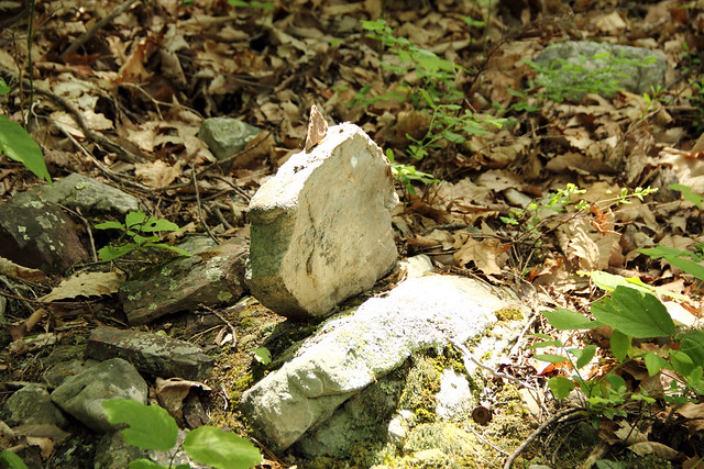
Valley Falls is really beautiful. As has happened previously, there was a wedding taking place when we arrived, and there were lots of people walking around on the rocks by the river.
If you want to get good pictures of the river, get there early, before the hordes arrive.


My cousin Ben would have been 34 today.
Just as we did last year, this year we hiked up Seneca Rocks in his memory.


Today’s excursion was biking along the Decker’s Creek Rail Trail.
When I was little, Decker’s Creek was dead. Due to acid mine drainage and other pollutants, nothing lived in the creek, it was an unappealing shade of orange, and it stank.
Today, I still wouldn’t drink from Decker’s Creek on a bet, but it’s a whole lot better, and the community is working to continue to improve it.


Ride details
Location: Mon River & Decker’s Creek Rail Trail
Distance: 22.3 miles
Elevation change: 693 feet
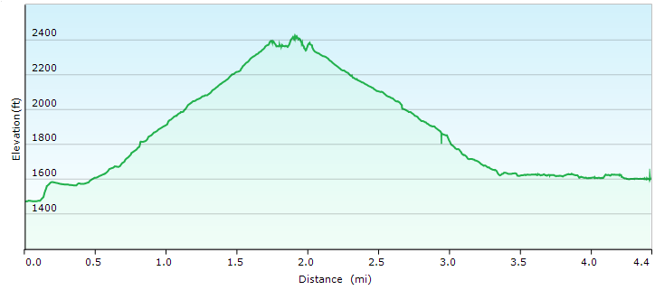
Friday we hiked up Seneca Rocks, in memory of my cousin Ben.
We hiked to the top without stopping, because that’s what Ben would have done. One the way down, however, I stopped many times for pictures.
Location: Seneca Rocks
Distance:4.4 miles
Elevation: 1092 feet


Most of the above pictures were taken from the viewing platform (noted with red arrow below), or several feet above. Because of COURSE I went past the STOP HERE DO NOT GO FURTHER sign.

The hike started approximately from where the next two pictures were taken, and then went up to the viewing platform (and just past).
Seneca Rocks at sunset:

Seneca Rocks mid-day:


Seneca Rocks Hike (gps map)
As I said, pretty much as soon as we get back to the car, the sun came out, and the day was beautiful from there on out.
And from these pictures, you can see why we wanted to hike Dolly Sods in the first place.


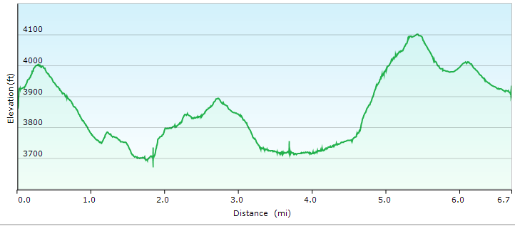
We took Thursday and Friday off, and traveled south. Thursday, we hiked Dolly Sods, which ended up being far less pleasant that it sounds, because 1) it rained for about 3/4 of the hike 2) it’s been raining for most of May and 3) about 2/3 of the way through our hike, the trail went through a swamp. And it’s been raining a lot.
Location: Dolly Sods National Wilderness Area
Trails: Blackbird Knob Trail, Upper Red Creek Trail, Dobbin Grade Trail (swamp), Beaver Dam Trail, and then Forest Road 75 back to the Blackbird Knob Trailhead)
Distance: 6.7 miles
Elevation: 838 feet
Here is what part of the non-swamp portion of the trail–the Upper Red Creek Trail–looked like:

Here’s another view of the Upper Red Creek Trail area. Yes, it was raining. And raining. And raining.

This is part of the Blackbird Trail, and approximately where we made the mistake of turning onto the Upper Red Creek Trail. Which would eventually lead us into the swamp.
I admit that even in the rain the Blackbird Trail was beautiful.


Here are the remains of the swamp I took out with me.

Dolly Sods Trails Hike (gps map)
After we finished our hike? The rain stopped, the skies cleared, and it was beautiful.
Location: Blackwater Falls
Trail: Pendleton Trace Trail, Dobbins House Trail, Pase Point Trail and into Monongahela National Forest
Distance: 3.9 miles
Elevation: 513 feet
This hike was actually three trails, that lead one to the other: Pendleton Trace Trail, Dobbins House Trail, and Pase Point Trail. We actually continued past the end of the Pase Point Trail into the Monongahela National Forest, where the trail is not maintained by the WV State Park system, but is in good shape, and not much more difficult than the Pase Point Trail. (At some point, I’d like to follow the path out and back.)
We started at the parking lot by the Pendleton Point Overlook. From there, to where we turned around (in the Monongahela National Forest) the hike was 3.9 miles. The elevation ascent was only 513 feet and 0.8% grade.


Here is the trail end:


Pase Point Trail (starting from Pendleton Point)
It rained for the better part of two weeks, so I was expecting a fair amount of water at Blackwater Falls. What we saw was more water going over the falls than I have ever seen. I didn’t even go down to the bottom of the falls overlook, because we’d have gotten soaked by the spray.
You can see Ekelata Falls in 2012 and in 2013.
Here’s what Elakala Falls looked like Saturday:

Here are some previous pictures of Blackwater Falls in 2013, 2010, and 2011. Seriously, go look at those pictures and compare them to what we saw Saturday.


Here’s a look at Blackwater Canyon, going away from the falls.

This is Pendleton Creek beneath the Pendleton Lake accessed from Dobbin House Trail. This was a difficult hike down to the creek, but well worth the view.


There is a bridge just below Pendleton Lake, and you can pretty easily get down to Pendleton Creek . It’s all shale, and it’s absolutely gorgeous. I took (approximately) a zillion pictures.
 >
>


Saturday we went to Blackwater Falls. It has rained for the better part of two weeks, which is why there was more water than I have ever seen coming over the falls. But those pictures will come later. Here are some of the flowers we saw.
Bluets (Quaker Ladies) Houstonia caerulea

False Solomon’s-seal Smilacina racemosa (I think)

Painted Trillium Trillium undulatum

Moccasin Flower Cypripedium acaule

Golden Ragwort (Senecio aureus) (I think)


It’s Primary Election Day, so after doing our Civic Duty, we headed out to Coopers Rock for a hike.
We hiked the Ridge Trail down to the Mont Chateau trail, hikeed the Mont Chateau trail, and then came back to Rock City via the Rhododendron Trail.
Location: Coopers Rock State Forest
Trails: Ridge & Rhododendron
Distance: 4.3 miles
Elevation: 959 feet
At the bottom of the Mont Chateau trail, I went off the path, and clambered along the creek. It was simply gorgeous–the pictures do not do it justice. (All GPS location stats are available if you click through to Flickr.)


It was a gorgeous hike.
Hike Map
Hike Stats:
4.3 miles
2 1/2 hours
959 feet elevation rise

Sunday we (again) hiked the Scott’s Run Trail at Coopers Rock. It was a gorgeous day, and the ground wasn’t nearly as muddy as we were expecting.
Location: Coopers Rock State Forest
Trails: Scott’s Run Trail
Distance: 4.5 miles
Elevation: 758 feet
You’ll notice that I take a lot of pictures of water. There are two reasons for this: first, I love running water, but second, because I continue to appreciate these clean clear streams, something we didn’t always have (and some areas of WV still don’t have). It like noting these positives.


All pictures are tagged with the Geo-coordinates if you click through to Flickr.
Out hike was 4 1/2 miles, and we ascended 758 feet, most of it rocky terrain.
Scott’s Run Trail
Sunday we hiked the Henry Clay Iron Furnace trail and then from there on the Mont Chateau Trail. Both were, of course, lovely.


Saturday it rained all afternoon and evening, and Sunday we woke up to snow, so after quick walk around our beighborhood, we drove out to Coopers Rock to take the same hike we took last weekend. (Scott’s Run Trail)
Well, mostly the same. We hiked down into the valley and returned from whence we came. I had no desire to walk up the steep, rocky run-off bed in the snow.
Regardless, it was a gorgeous hike, even if my ankle is very sore now.


If you click through to Flickr, all photos are marked on the map with their GPS coordinates, which should give you the ability to compare last week to this week.
A very different walk from last week, but just as beautiful.
Data:
3.3 miles
292 feet elevation gain
Moving time: 1:52


