Random (but not really)

Tuesday, April 16, 2019

Hiking WV: Canaan Valley State Park

One of the reason I wanted to go hiking was because I finally replaced my GPS.

I’ve had the Oregon 550t since 2013, and it remains a workhorse. However, it’s accuracy was getting problematic. If we’re hiking a loop, our starting and ending elevations should be approximately the same.

The last loop we hiked our starting elevation was 1592 and the ending elevation was 1637. And our peak elevation was 1774 feet going out, and 1850 feet coming back. Those elevations should have been the same, not 45-76 feet different.

So after a lot of back and forth and a month of thinking about it I got a Garmin Oregon 700.

There have been a lot of improvements in the past six years, and although I liked the Orgeon 550t, I LOVE the 700.

The point of all this is what I wanted to use the new GPS.

So our first use was one of my favorite trails.

Location: Canaan Valley SP
Trail: Blackwater River Trail
Distance: 0.8 miles
Elevation: 3202-3261 (78 feet gain)

2019-04-13_Canaan_002

2019-04-13_Canaan_019

GPS was perfect, and the hike was lovely; Win win!

Written by Michelle at 8:00 am    

Comments (0)  Permalink

Categories: Hiking,Photos,State Park / Forest,West Virginia  

Sunday, March 17, 2019

Hiking WV: Babcock State Park & NRG

Finally! A Saturday without rain and mud!

After scanning the regional weather, we headed south towardsNew River Gorge, but as always happens, I said, “Oh! Can we stop by Babcock?”

Since there weren’t that many people, and since the day was beautiful, we decided to take the Lake View Trail, which we hadn’t hiked before.

It was gorgeous.

Location: Babcock State Park
Trail: Lake View Trail
Distance: 1.7 miles
Elevation: 2404-2596 ft

2019-03-16_Babcock_025

2019-03-16_Babcock_021

Of course I took a picture of the grist mill.

2019-03-16_Babcock_015

We went onto New River Gorge for a hike there, and decided to take the Bridge View Trail, which… was a view of the underside of the bridge. Which is fine, but not what I was thinking (I was thinking a view like Long Point, but from the other side.)

Location: New River Gorge
Trail: Bridge View Trail
Distance: 1.6 miles
Elevation: 1587-1852 feet (519 feet climb)

It was steep (with switchbacks) and rocky, with steps made from the area stones.

2019-03-16_Babcock_028

Not one of my favorite hikes, but I was outside in the woods, so that made it better than many other things.

Written by Michelle at 9:50 am    

Comments (0)  Permalink

Categories: Hiking,National Park / Forest,Photos,State Park / Forest,West Virginia  

Wednesday, January 16, 2019

You Want to Spend Money on WHAT?!

There are not words strong enough for me to describe how I feel about this: Three delegates want to divert $10 million from WV surplus to fund border wall.

I love West Virginia.

But this? This is despicable.

Idiot 1, R-Upshur, Idiot 2, R-Lewis, and Idiot 3, R-Webster

First of all, this is no more and no less a political game.

Second, WV is struggling so much, the idea of throwing away money on ANYTHING that doesn’t directly benefit the state enrages me.

Let’s take a look at just a couple of things the state could be spending money on.

Education

Estimated average annual salary of teachers in public elementary and secondary schools, by state

Source: National Center for Education Statistics, https://nces.ed.gov/

Here are the numbers for the five states at the bottom of that list.

Colorado 46,506
West Virginia 45,701
Oklahoma 45,245
Mississippi 42,925
South Dakota 42,668

Here we see how WV compares to the surrounding states:

Maryland 66,961
Pennsylvania 65,863
Ohio 57,000
Kentucky 52,339
Virginia 51,049
West Virginia 45,701

See also: https://www.bls.gov/oes/current/oes_wv.htm#25-0000, https://www.wvea.org/content/goal-set-starting-teacher-salaries-west-virginia

——

Let’s move on.

Broadband

Last year I ranted about high speed internet access .

These numbers are the percent citizens in the selected counties with access to broadband internet.
Pocahontas = 0%
Calhoun = 0%
Ritchie = 14.0%
Clay – 16.7%
Monroe = 17.9%
Barbour 21.4%

That’s right. We have two counties where there is NO ACCESS AT ALL to high speed internet.

You can go to my original post for the sources and data.

——

Moving along again.

Food

You may remember I’ve also ranted about the number of food deserts in WV. The data in that post was from 2017, so it’s about two years out of date. Unfortunately, I can’t update it because of the government shutdown means much of my source data is currently inaccessible, but here’s what I found.

West Virginia has 14 counties that contain major food deserts [C]–cities are were more than 20 miles from “grocery stores, farmers’ markets, and healthy food providers.” The entire county of Gilmer is a food desert. Nine (9) of those counties with food deserts are NOT along the state border, and nine (9) of those counties also have a mean yearly income less than $50,000.

Here’s a more recent articles about food deserts in WV:
In McDowell County ‘food desert,’ concerns about the future

——

Let’s continue further.
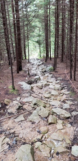
Roads

One of the things I will go on about are the roads in WV.

Here are the “major” roads in WV. The heavy green and red lines are our interstates.

The rest of those highways are anything from four lane divided highways to two lane roads with 11% grades and hairpin turns. (Note the significant amounts of area without interstates or highways.)

Outside of those “major” roads?

Well, I’ve mentioned them before. The GPS Really Is Trying TO Kill Us, Traveling WV: The GPS Really Is Trying To Kill You

Also: ‘Enough is enough’ say advocates for better W.Va. road maintenance

——

One final thing (for now).

Water

Lots of people heard about the crisis when the chemical spill in Charleston left more than 300,000 without usable water in 2015.

Thing is, in many areas of WV, lack of safe drinking water is a way of life, rather than a one time event.

Today, an estimated $17 billion is needed to correct water infrastructure challenges for all of West Virginia, per the Infrastructure and Jobs Development Council, a state agency that serves as a clearinghouse for funding on infrastructure projects. That figure is almost four times the state’s entire budget for 2018.

Stirring the Waters: In Southern WV, days without water are a way of life

$17 billion so all of WV can have access to clean drinking water.

Here’s an excerpt from a WV DEP report on streams and rivers in WV:

(There are currently) 1,142 impaired stream segments, covering approximately 5,091 stream miles that are impaired…

The most common criteria violations in West Virginia streams in order of total stream miles are:
Fecal coliform
Total iron (warmwater)
Biological impairment, as determined through application of the West Virginia Stream Condition Index
Dissolved Aluminum
pH
PCBs
Selenium

Why is stream and river health important? Because here in WV, that’s where our drinking water comes from. Here’s a bit from our water company on where my water comes from.

In 2016, MUB produced 3.67 billion gallons of drinking water, an average of 10.868 million gallons per day. The main source of drinking water for the Morgantown area is surface water from the Monongahela River, which supplied 75.7 percent of the area’s drinking water. The remaining 24.3 percent of our raw water supply was taken from the Cobun Creek reservoir.

And I’ll give you three guesses as to where our treated sewage goes.

Here’s another article on drinking water in WV:
Millions consumed potentially unsafe water in the past 10 years

So, here in WV we have underpaid teachers. Many areas WV lacks the roads for industry and manufacturing to be willing to move here. Significant stretches of the state are food deserts and lack access to safe tap water. And we didn’t even get to the opioid crisis.

All that? THAT’S why we lack jobs and economic growth.

You want to fix WV? Improve education. Build roads and infrastructure. Fix the water supply. Until those things happen, we’ll remain at the bottom. And with the ideas of the Republicans currently in power, that won’t be happening any time soon.

Written by Michelle at 10:38 am    

Comments (0)  Permalink

Categories: Politics,West Virginia  

Monday, October 22, 2018

Traveling WV: Paw Paw Tunnel

Technically, this is in Maryland.

But it is labelled the Paw Paw tunnel, and Paw Paw is in WV.

I can’t believe we’d never been there before.

When building the C&O canal, they were in a race against the completion of rail lines, so they decided the it would be easier to build a tunnel than to follow the river (understandable really, because the river is really twisty and the riverbanks weren’t necessarily good for canal building).

It’s pretty impressive.

2018-10-20_Paw_Paw_006

2018-10-20_Paw_Paw_059

We totally counted all markers and found the four markers for shafts.

2018-10-20_Paw_Paw_062

2018-10-20_Paw_Paw_055

2018-10-20_Paw_Paw_037

Oops.

2018-10-20_Paw_Paw_040

2018-10-20_Paw_Paw_036

2018-10-20_Paw_Paw_025

2018-10-20_Paw_Paw_023

2018-10-20_Paw_Paw_019

2018-10-20_Paw_Paw_017

2018-10-20_Paw_Paw_016

Written by Michelle at 6:00 am    

Comments (2)  Permalink

Categories: Maryland,National Park / Forest,Photos  

Sunday, October 21, 2018

Traveling WV: Berkeley Springs

After a long search, we found that there was a break in the rain on Saturday in the Berkeley Springs area. So that’s where we headed.

This is a beautiful, and we spent some time wandering around the town. I wouldn’t want to live on the main street, but it is a lovely little town.

The pools fed by the springs were quite high–higher than I ever remember seeing them.

2018-10-20_Berkeley_Springs_002

They were also as pretty as they always are.

For something different, instead of going to Cacapon, went up to what used to be called Panorama Peak. Still not much color, but beautiful never-the-less.

2018-10-20_Panorama_Peak_010

2018-10-20_Panorama_Peak_017

2018-10-20_Panorama_Peak_024

Written by Michelle at 7:24 pm    

Comments (2)  Permalink

Categories: Photos,State Park / Forest,West Virginia  

Monday, October 15, 2018

A Train! A Train! The Potomac Eagle

Our friends ended up with two extra tickets for the Potomac Eagle in Saturday, and asked if we’d be able to go with them. A train ride AND time with two lovely small people (and their parents)? Of course!

Three of them rode in the gondola through the trough. Michael and I and one of the small people declined. I was more interested in the scenery than the eagles, and the small person thought the gondola would be too loud, since it was behind the engine.

It was a beautiful day, and there were actually eagles, but I enjoyed the view (even if there was almost no fall color).

Look an old house!

2018-10-13_Potomac_Flyer_023

Look! A couple of walls that used to be a house!

2018-10-13_Potomac_Flyer_031

Interesting rocks!

2018-10-13_Potomac_Flyer_051

The river!

2018-10-13_Potomac_Flyer_048

Fields and mountains!

2018-10-13_Potomac_Flyer_016

An excellent day!

Written by Michelle at 6:00 am    

Comments (0)  Permalink

Categories: Photos,West Virginia  

Sunday, October 14, 2018

Hiking WV: Canaan Valley

There was also a dearth of color at Canaan Valley (and Blackwater Falls).

Still pretty though.

2018-10-12_Canaan_Valley_051

2018-10-12_Canaan_Valley_055

2018-10-12_Canaan_Valley_053

Written by Michelle at 7:16 pm    

Comments (0)  Permalink

Categories: Hiking,Photos,State Park / Forest,West Virginia  

Hiking WV: Seneca Rocks

Since the weather was forecast to be nice, and Michael had the day off, Saturday we decided to head down to Seneca Rocks, in hopes of catch some fall color.

The weather was lovely, but there was a distinct lack of fall color.

2018-10-12_Seneca_Rocks_049

Location: Seneca Rocks
Trail: Seneca Rocks Trail
Distance: 3.7 miles
Elevation: 1573-2520 feet (1003 ft rise)

Hike Up
1.2 miles
1611-2446 feet
33 minutes

It doesn’t look like there’s that much water going over the bridge!

2018-10-12_Seneca_Rocks_002

Guess who had wet feet for this hike?

One of the reasons I wanted to make this hike on a Friday and not Saturday is that it tends to be really busy on Saturdays, and I selfishly prefer solitude when at the top of the rocks.

2018-10-12_Seneca_Rocks_022

2018-10-12_Seneca_Rocks_007

2018-10-12_Seneca_Rocks_025

Written by Michelle at 7:10 pm    

Comments (0)  Permalink

Categories: Hiking,National Park / Forest,Photos,West Virginia  

Monday, October 1, 2018

Hiking WV: Cranberry Wilderness

After a week of rain, Saturday was clear, so we headed to the Cranberry Wilderness, which has become one of my favorite places, since it is far less visited that most other spots in WV.

We hiked two shorter trails, wanting the views as much as the hiking.

Location: Cranberry Wilderness
Trail: Red Spruce Trail
Distance: 2.3 miles
Elevation: 4386-4722 feet (420 ft gain)

Is that… a bear track? (Click through to Flickr for a comparison picture.)

2018-09-29_Cranberry_Wilderness_001

The trail at the top of the mountain was unbelievably gorgeous. Look at that! So beautiful!

2018-09-29_Cranberry_Wilderness_005

Because Red Spruce Knob is the highest peak in the area, there was a fire tower here at one point. That tower is long gone, and most of the overlook is overgrown.

2018-09-29_Cranberry_Wilderness_007

Still worth the hike.

Trail: High Rocks Trail
Distance: 3.2 miles
Elevation: 4312-4507 feet (471 ft gain)

The trail to High Rocks was possibly one of the easiest we’ve ever hiked in the Mon Nat’l Forest. We kept waiting for it to get super muddy or terribly rocky or ridiculously steep; Nope. It was a very easy hike.

2018-09-29_Cranberry_Wilderness_009

It was a ridiculously easy hike, for the view at the end.

Written by Michelle at 6:00 am    

Comments (0)  Permalink

Categories: Hiking,National Park / Forest,Photos,West Virginia  

Wednesday, September 26, 2018

Hiking WV: Dolly Sods

Since we had a long weekend and didn’t have to drive, we wanted to do a long hike on Friday.

There are so many places to choose from in the Canaan Valley area, but we eventually settled on Dolly Sods, and a trail we’d wanted to hike before, in the hopes that it being a Friday morning we wouldn’t see so many people.

We saw… fewer people than we would on a Saturday, but we still saw more people than I particularly wanted to on a hike in the wilderness.

Location: Dolly Sods Wilderness
Trails: Rocky Ridge, Blackbird Knob Trails
Distance: 7.6 miles
Elevation: 3757-4184 feet (1137 feet gain)

2018-09-21_Dolly_Sods_038

2018-09-21_Dolly_Sods_054

Blackbird Knob Trail

2018-09-21_Dolly_Sods_057

2018-09-21_Dolly_Sods_049

Yes, the trail really is that rocky and wet and muddy. So many people hike Dolly Sods that everything is very worn and never gets a chance to recover.

Despite the wilderness being busier than one would expect, views like this make the trip worth it.

2018-09-21_Dolly_Sods_013

Written by Michelle at 6:00 am    

Comments (0)  Permalink

Categories: Hiking,National Park / Forest,Photos,West Virginia  

Tuesday, September 25, 2018

Blackwater Falls & Elakala Falls

Since it was raining off and on (and then on and on and on) we went to the main falls three different days to see the water levels. (Because of COURSE I needed to have points of comparisons.)

Saturday:

2018-09-22_Blackwater_Falls_033

Sunday:

2018-09-23_Blackwater_Falls_072

Monday:

2018-09-24_Blackwater_Falls_001

I also took video, because of course I did.

On Saturday we also did the scramble down to the base of Elakala Falls.

2018-09-22_Blackwater_Falls_053

2018-09-22_Blackwater_Falls_043

2018-09-22_Blackwater_Falls_038

Written by Michelle at 5:00 pm    

Comments (0)  Permalink

Categories: Photos,State Park / Forest,West Virginia  

Hiking WV: Blackwater Falls State Park

We hadn’t been out to Pace Point in awhile, so we decided that’d be our easier hike after a long hike at Dolly Sods.

Location: Blackwater Falls State Park
Trails: Pendleton Trace, Dobbin House and Pase Point Trails
Distance: 2.9 miles
Elevation: 3009-3170 feet

2018-09-21_Blackwater_Falls_010

Location: Blackwater Falls State Park
Trails: Lindy Point Trail, Canaan Loop Road
Distance: 1.4 miles
Elevation: 3139-3216 feet

The next day we decided to head out to Lindy Point (and the stream along Canaan Loop Road)

2018-09-22_Blackwater_Falls_058

Here’s the stream that crosses Canaan Loop Road. I haven’t seen that much water there before.

2018-09-22_Blackwater_Falls_068

We ended up having a multi-day debate as to whether you can see Lindy Point from Pase Point (and vice versa)

I say you can’t, Michael says you can.

Written by Michelle at 6:00 am    

Comments (0)  Permalink

Categories: Hiking,Photos,State Park / Forest,West Virginia  

Monday, September 24, 2018

Hiking WV: Canaan Wildlife Refuge

We did two hikes at the Canaan Wildlife Refuge. A hike along the Beale Trail that’d we’d done before, but chose because it was easy, because it was raining.

The first hike was new to us, partway up Cabin Mountain. We considered hiking to the top of the trail, but were afraid it’d be dark on the way down, and I’d trip over everything.

Location: Canaan Valley Wildlife Refuge
Trails: Middle Ridge and Sand Run Trails
Distance: 3.6 miles
Elevation: 3246-3571 feet (597 ft gain)

2018-09-22_Canaan_Valley_WR_009

Is that… a bridge?

2018-09-22_Canaan_Valley_WR_003

Yes! A completely useless bridge!

2018-09-22_Canaan_Valley_WR_002

Michael: They need to mow this bridge.

2018-09-22_Canaan_Valley_WR_012

All kidding aside, it was a nice, if rather steep hike, and I definitely want to hike up to the top of the Cabin Mountain Trial to see the view.

Location: Canaan Wildlife Refuge
Trail: Beall Trails
Distance: ~3 miles (I forgot to turn on the GPS until half a mile in)
Elevation: 3151-3375 feet

It’s raining. Where shall we hike? A bog of course!

At the Bog Overlook

2018-09-23_Canaan_Valley_WR_002

2018-09-23_Canaan_Valley_WR_009

Written by Michelle at 6:53 pm    

Comments (0)  Permalink

Categories: Hiking,National Park / Forest,Photos,West Virginia  

Monday, September 17, 2018

Hiking WV: Coopers Rock

Sunday we made it to my happy place.

Location: Coopers Rock
Trails: Rhododendron, Notmucha, Clay Run, Mont Chateau Trails
Distance: 4.6 miles
Elevation: 1511-2156 ft (851 feet rise)

Written by Michelle at 7:07 pm    

Comments (0)  Permalink

Categories: Hiking,State Park / Forest,West Virginia  
« Previous PageNext Page »

Powered by WordPress