Sunday Flower Pr0n: WV Botanic Garden
Please enjoy some hot butterfly on flower action.


Please enjoy some hot butterfly on flower action.
It was a gorgeous day for a hike in Canaan. And also for wandering around Davis, after eating ice cream.
Location: Canaan Mountain Backcountry
Trail: Table Rock Trail
Distance: 2.3 miles
Elevation: 3385-3500 feet
Temperature: 72 F


Most of our hiking was with small people this weekend, so they were short, easy hikes.
We did do one hike for ourselves–I’ve wanted for awhile to scramble down to the falls that are visible across the gorge from Pendleton Point. So, we did.
The Canaan Valley SP hike is one I highly recommend for small people. It’s short, it’s relatively flat, and it’s gorgeous.
Location: Canaan Valley State Park
Trail: Blackwater River Trail
Distance: 0.9 miles
Elevation: 3252-3337 feet

Here’s the hike we did for me.
Location: Blackwater Falls
Trail: Elekala Falls and off trail
Distance: 0.9 miles
Elevation: 3031-3219 feet
Here are the main falls, the ones directly below the lodge.

The next set of falls:

Next falls down:

Hey look! Pendleton Point!

And finally the section of falls visible from Pendleton Point:

The scramble wasn’t awful, but the rhododendron is thick, which always makes things difficult.
I wouldn’t mind going down when it was a little drier, just so I could explore a little more. (This is me: I refuse to clamber along falls when there is a fast flow of water. Because I’m not a complete idiot.)
I didn’t get solo pictures of each kid, because my time was short and there were various schedule issues. But these are some of the pictures that I loved.


And that was MY past weekend.
Flowers are from the Cranberry Wilderness and the Falls of Hills Creek.
The way the light turned out, I almost feel embarrassed looking at this display of naughty bits.

Lots of Bee Balm


Is this a white Bee Balm? Because that’s what it looks like to me.

We’ve wanted to do a long hike in the Cranberry Wilderness for quite awhile, however, a 2+ hour drive, then a long hike, then another 2+ hour drive was… unappealing.
So we’ve spent the past couple months gather things we’d need for an overnight trip where there aren’t hotels, Michael rented a tent from the Rec Center, and we were off!
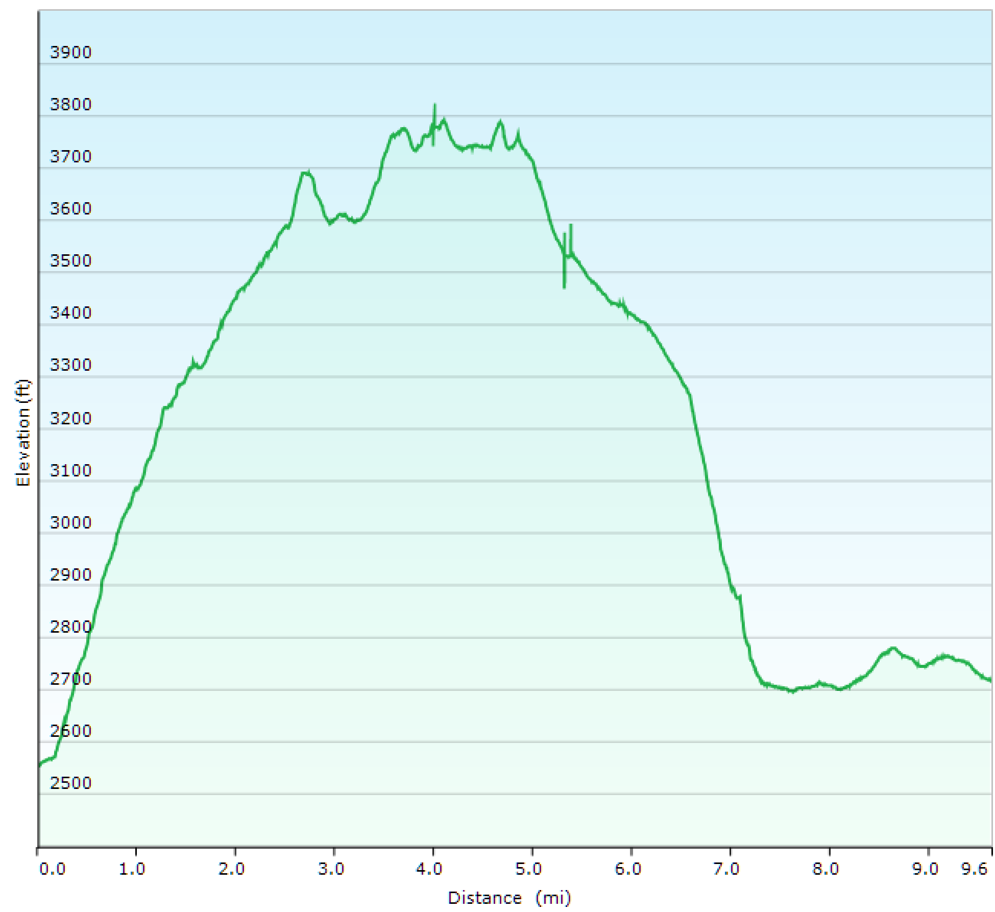
Location: Cranberry Wilderness
Trails: North-South and Lick Branch trails and FR 76
Distance: 9.6 miles
Elevation: 2552-3795 feet (1618 feet elevation gain)
One of the books I have recommend this hike in the opposite direction.
No.
The direction we went–North-South trail followed by Lick Creek Trail and then taking the road back is the way you want to do this look.
First, the North South trail is fine, but it’s steep from the campsite to the ridgeline–about a 9% grade. And although it’s pleasant enough, it’s not the most rewarding view.
Although we did amuse ourselves.

That sign? It’s warning you that no motorized vehicles are allowed on the Wilderness.

There is another sign, in a wide view showing you the the surrounding trail.
There is no way you could GET a motorized vehicle to where these signs were, unless it was a hovercraft, and even then it’d be chancy. There were endless fallen trees, lots of going through narrow passages etc.
So, I giggled every time I saw those signs someone was forced to place in an area already inaccessible to motorized vehicles.
Also found a newly placed marker!

And several swarms of butterflies.

But, it wasn’t anything spectacular. No views down into the various valleys, etc.
Here is the start of Lick Creek at the top of the Lick Creek trail. Now things are starting to get pretty!

And this is the end of the trail–pretty much visible from the forest road (and by road, I mean Fire Trail type road, closed to cars but accessible in an emergency).

Why put the prettiest thing at the start of the strenuous part of the hike? What is your reward for finishing? A 9% grade? Bah humbug.
Additionally, since the last couple miles were on the forest road, that meant we were able to stretch our legs and walk out the kinks from the ascent and descent. Nice! And the road is along the river! So pretty!
So my recommendation is start this loop from the gate. Unless you’re a masochist, in which case this probably isn’t a long or miserable enough hike for you, so why bother?
Yesterday kept threatening thunderstorms all day, so no hiking. So today we went down to the Mont Chateau trail. The creek was running really high.
Location: Coopers Rock State Forest
Trails: Rock City, Ridge, Mont Chateau, Rhododendron Trails
Distance: 4.3 miles
Elevation: 1497-2107 feet (724 feet gain)
Temperature: 68-72 F
This is where I usually build my rock piles. As you can see, everything previous was washed away.

Much deeper water than normal. Plus MUCH colder.

Water was cascading down both sides of the split. Not fast enough to be dangerous, but fast enough for me to be extra careful.

Nature left this, perhaps in compensation for knocking down all my rock piles.

Because Michael had to go into work yesterday, we didn’t get out to the woods until late, so we took the Iron Furnace trail, which is rocky but much less steep, down to the Mont Chateau Trail, and then played around in the creek for awhile.
Because what’s the point of being an adult if you can’t play in the creek?
Location: Coopers Rock
Trails: Iron Furnace, Mont Chateau Trails
Distance: 3.4 miles
Elevation: 1517-1946 feet (810 feet gain)
Temperature: 79-78 F
Last week’s storm knocked down my rocks, so I stacked up more.


I would have stayed longer if I wasn’t worried about stumbling on my way out in the dark.
Happy Sunday! Have some flower pr0n!


Since we were already in the area, we decided to stop by Blackwater Falls and see what the heavy rainfall was producing.
It produced a lot of water going over the falls and down the river.
We didn’t hike any full trails, just wandered out to spots that I knew would be pretty.


I really like the Blackwater Trail at Cannan Valley SP. It’s a very short trail, with almost no elevation gain, but it goes through three different kinds of landscape–the prettiest of which is beside the winding Blackwater River. If you’re looking for a trail to take small kids, this is the one you want.
Location: Canaan Valley State Park
Trail: Blackwater Trail
Distance: 1.0 miles
Elevation: 3213-3275 feet


We managed to spent the night in Canaan, so we took a long hike at Dolly Sods (most of our Saturday hikes are limited by the fact we have to drive 2-3 hours there and then 2-3 hours home after hiking). So it was nice to know that we could have until we were tired and not have to worry about a long drive afterwards.
Location: Dolly Sods
Trails: Valley View, Rocky Ridge, Raven Ridge, Bear Rocks Trails
Distance: 11.0 miles
Elevation: 3817-4198 feet (1447 feet ascent)
I took about a zillion pictures, because the Dolly Sods area is gorgeous.


More day lilies are blooming! Hooray!
Why yes, I really do have many different cultivars of day lilies! (This doesn’t include the lemon lilies we got from Michael’s grandmother that bloom in early spring, and the Stella D’Oros that will bloom repeatedly.)


Some of these can probably be split. If anyone is interested, let me know–assuming I can be bothered to split them this year. O.o
My day lilies are blooming! Unfortunately they’re kinda beat up. But the balloon flower and hostas look nice!


Powered by WordPress


As an Amazon Associate I earn from qualifying purchases.
So if you click through on one of the book links I might get a half penny or so and eventually be able to buy a new book to read!
