Random (but not really)

Saturday, July 5, 2014

Hiking West Virginia: Coopers Rock, Mont Chateau Trail to Cheat Lake

Location: Coopers Rock
Trails: Henry Clay Iron Furnace Trail, Mont Chateau Trail to Cheat Lake
Distance: 5.3 miles
Elevation: 1371 feet

Henry Clay Iron Furnace Trail (one way)
Distance: 0.9 miles
Elevation: 267 feet

Mont Chateau Trail to Cheat Lake (one way)
Distance: 1.4 miles
Elevation: 739 feet

The best park of the hike was switching from boots to water shoes and hiking in the creek. We managed 0.6 miles in about an hour, which was pretty good, since it was a lot of trying to figure out how to move get up rocks or around deep pools.

The balanced rocks are still there!

20140704_Coopers_Rock_Mont_Chateau_028

20140704_Coopers_Rock_Mont_Chateau_035

Coopers Rock

20140704_Coopers_Rock_Mont_Chateau_062

20140704_Coopers_Rock_Mont_Chateau_068

20140704_Coopers_Rock_Mont_Chateau_042

Map of complete hike

Written by Michelle at 11:33 am    

Comments (0)  Permalink

Categories: Hiking,Photos,State Park / Forest,West Virginia  

Friday, July 4, 2014

Hiking West Virginia: North Bend State Park

Thursday, on our way back from the Mountain State Arts and Craft Fair at Ripley, we stopped at North Bend State Park for a brief hike.

Location: North Bend State Park
Trails: Overhanging Rock Trail, Extra Mile Trail, Oil Well Access Trail to North Bend Rail Trail
Distance: 2.4 miles
Elevation: 375 feet

It’s a rail trail, so it’s quite flat (for WV).

The Extra Mile trail is a paved and has handrails on both sides, for visual and mobility limited visitors. (Amusingly, we saw this at the END of the trail, so came up with many theories as to why there were railings on both sides of the paved trail.)

It links to the North Bend Rail trail, at Tunnel 13 and the bridge over Bonds Creek.

20140703_North_Bend_State_Park_012

Tunnel 13, South Entrance

20140703_North_Bend_State_Park_008

Tunnel 13, North Entrance

20140703_North_Bend_State_Park_010

Remains of train platform:

20140703_North_Bend_State_Park_016

20140703_North_Bend_State_Park_019

Map of hike

Written by Michelle at 7:39 pm    

Comments (0)  Permalink

Categories: Hiking,Photos,State Park / Forest,West Virginia  

Monday, June 30, 2014

Hiking WV: Coopers Rock, Scotts Run & Roadside Trails

Location: Coopers Rock State Forest
Trails: Scott Run and Roadside Trails
Distance: 5.3 miles
Elevation Gain: 1038 ft

Scott Run Trail
2.9 miles
763 ft elevation gain

Roadside Trail
1.8 miles
187 ft elevation gain

20140628_Coopers_Rock_058

20140628_Coopers_Rock_033

20140628_Coopers_Rock_015

20140628_Coopers_Rock_011

20140628_Coopers_Rock_066

Written by Michelle at 6:00 am    

Comments (0)  Permalink

Categories: Hiking,Morgantown,State Park / Forest,West Virginia  

Thursday, June 19, 2014

Hiking West Virginia: Coopers Rock

Location: Coopers Rock State Forest
Trails: Rhododendron Trail, Mont Chateau Trail, Ridge Trail, Rock City Trail
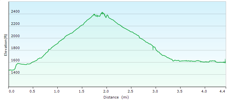
Distance: 5.4 miles
Elevation: 1259 feet

Sunday we took a nice long hike at Coopers Rock. We hike most of the way down to the lake, but I’d spent a very long time playing in the stream, so decided to turn around so we wouldn’t have to climb an additional 100 feet.

Towards the end of Mont Chateau trail (or rather, before we turned around) we came across this waterfall, which I would love to figure out how to hike down to without injuring myself.

20140615_Coopers_Rock_070

But the best part was spent in the creek. I brought a pair of water shoes, so when we got down to the area I liked so much previously, I rolled up my pants, switched my boots for the water shoes and clambered around in the stream.

It was cold.

But it also felt really good on my bad ankle, so I wasn’t complaining at all.

20140615_Coopers_Rock_021

The stream was gorgeous, and running quite high, as we’ve had rain rain rain rain rain.

20140615_Coopers_Rock_004

20140615_Coopers_Rock_011

I have my Rebel XSi back (I’d loaned it to my parents for their trip to Alaska) and as much I find it so much easier (and less nerve racking) to carry the XSi, the pictures aren’t quite as sharp as my other camera.

But I’m not taking my good camera into a stream. So I’ll just have to live with it. :)

20140615_Coopers_Rock_067

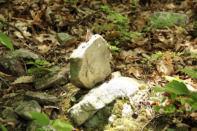
And then I came across a scene that made my day.

20140615_Coopers_Rock_032

You could not have seen that from the bridge. You had to get down and hike in (or alongside) the stream.

20140615_Coopers_Rock_038

20140615_Coopers_Rock_057

20140615_Coopers_Rock_056

Thank you, to whoever left that transient art. It’s marvelous.

GPS Map of Hike

Written by Michelle at 6:00 am    

Comments (0)  Permalink

Categories: Hiking,Photos,State Park / Forest,West Virginia  

Monday, June 16, 2014

Hiking West Virginia: Tomlinson Run State Park

Location: Tomlinson Run State Park
Trails: Fuse Trail, Dynamite Shack Trail, Beech Trail
Distance: 1.7 miles
Elevation: 423 feet

Here is one of the views.

20140614_Tomlinson_Run_048

And here is the stuff I found really interesting:

20140614_Tomlinson_Run_028

20140614_Tomlinson_Run_030

20140614_Tomlinson_Run_036

20140614_Tomlinson_Run_042

20140614_Tomlinson_Run_046

20140614_Tomlinson_Run_003

EVERYTHING is not permitted!

20140614_Tomlinson_Run_015

I almost forgot, you have to cross a stream at one point, which, considering how much it’s rained (and rained and rained) wasn’t easy going.

DSC00227

Written by Michelle at 6:00 am    

Comments (0)  Permalink

Categories: Hiking,Photos,State Park / Forest,West Virginia  

Monday, June 9, 2014

Hiking WV: Lost River State Park

Location: Lost River State Park
Trails: White Oak Trail
Distance: 2.2 miles
Elevation Change: 640 feet

There were several miscalculations made on Saturday: how long it would take to get to Lost River State Park and how much food we’d want to bring.

The end result was that I ended up getting too hungry, my blood sugar dropped, and I felt off for much of the rest of day. It happens, but it’s frustrating, because it was a gorgeous day for hiking.

Lost River State Park would be a great park to take kids: lots of playgrounds and swimming pool. I wish we’d have hiked more, but it was a longer drive than we were interested in for the hiking.

20140607_Lost_River_State_Park_015

20140607_Lost_River_State_Park_004

20140607_Lost_River_State_Park_003

20140607_Lost_River_State_Park_020

GPS Map of White Oak Trail

Written by Michelle at 6:00 am    

Comments (0)  Permalink

Categories: Hiking,Photos,State Park / Forest,West Virginia  

Thursday, May 29, 2014

Hiking West Virginia: Valley Falls State Park

Saturday we were still pretty tired from the previous days’ hikes, so we just went to Valley Falls State Park to take pictures of the water and maybe take a short hike.

We hiked the Rhododendron trail to the Dogwood trail, and then the signage got a little wonky, and we were following signs that simply said “Picnic Area”. We came out on the Rocky Trail, but were only on that for a little bit. So who knows where were actually were.

Location: Valley Falls State Park
Trails: Rhododendron Trail, Dogwood Trail, ??? Trail
Distance: 3.2 miles
Elevation: 615 feet

Valley Falls hike (gps map)

Written by Michelle at 8:00 am    

Comments (0)  Permalink

Categories: Hiking,State Park / Forest,West Virginia  

Saturday, May 24, 2014

Hiking West Virginia: Seneca Rocks

Friday we hiked up Seneca Rocks, in memory of my cousin Ben.

We hiked to the top without stopping, because that’s what Ben would have done. One the way down, however, I stopped many times for pictures.

Location: Seneca Rocks
Distance:4.4 miles
Elevation: 1092 feet

20140523_Seneca Rocks_083

20140523_Seneca Rocks_087

20140523_Seneca Rocks_056

Most of the above pictures were taken from the viewing platform (noted with red arrow below), or several feet above. Because of COURSE I went past the STOP HERE DO NOT GO FURTHER sign.

Seneca_Rocks_Viewing_Platform

The hike started approximately from where the next two pictures were taken, and then went up to the viewing platform (and just past).

Seneca Rocks at sunset:

20140522_Seneca Rocks_018

Seneca Rocks mid-day:

20140523_Seneca Rocks_167

20140523_Seneca Rocks_109

20140523_Seneca Rocks_128

20140523_Seneca Rocks_074

20140523_Seneca Rocks_076

Seneca Rocks Hike (gps map)

Written by Michelle at 8:00 pm    

Comments (0)  Permalink

Categories: Hiking,National Park / Forest,Photos,West Virginia  

Hiking West Virginia: Dolly Sods

We took Thursday and Friday off, and traveled south. Thursday, we hiked Dolly Sods, which ended up being far less pleasant that it sounds, because 1) it rained for about 3/4 of the hike 2) it’s been raining for most of May and 3) about 2/3 of the way through our hike, the trail went through a swamp. And it’s been raining a lot.

Location: Dolly Sods National Wilderness Area
Trails: Blackbird Knob Trail, Upper Red Creek Trail, Dobbin Grade Trail (swamp), Beaver Dam Trail, and then Forest Road 75 back to the Blackbird Knob Trailhead)
Distance: 6.7 miles
Elevation: 838 feet

Here is what part of the non-swamp portion of the trail–the Upper Red Creek Trail–looked like:

20140522_Dolly_Sods_008

Here’s another view of the Upper Red Creek Trail area. Yes, it was raining. And raining. And raining.

20140522_Dolly_Sods_005

This is part of the Blackbird Trail, and approximately where we made the mistake of turning onto the Upper Red Creek Trail. Which would eventually lead us into the swamp.

I admit that even in the rain the Blackbird Trail was beautiful.

20140522_Dolly_Sods_004

20140522_Dolly_Sods_003

Here are the remains of the swamp I took out with me.

20140523_Muddy_003

Dolly Sods Trails Hike (gps map)

After we finished our hike? The rain stopped, the skies cleared, and it was beautiful.

Written by Michelle at 9:47 am    

Comments (0)  Permalink

Categories: Hiking,National Park / Forest,Photos,West Virginia  

Tuesday, May 20, 2014

Hiking West Virginia: Blackwater Falls, Dobbin House and Pase Point Trails

Location: Blackwater Falls
Trail: Pendleton Trace Trail, Dobbins House Trail, Pase Point Trail and into Monongahela National Forest
Distance: 3.9 miles
Elevation: 513 feet

This hike was actually three trails, that lead one to the other: Pendleton Trace Trail, Dobbins House Trail, and Pase Point Trail. We actually continued past the end of the Pase Point Trail into the Monongahela National Forest, where the trail is not maintained by the WV State Park system, but is in good shape, and not much more difficult than the Pase Point Trail. (At some point, I’d like to follow the path out and back.)

We started at the parking lot by the Pendleton Point Overlook. From there, to where we turned around (in the Monongahela National Forest) the hike was 3.9 miles. The elevation ascent was only 513 feet and 0.8% grade.

20140517_Blackwater_Falls_061

20140517_Blackwater_Falls_069

20140517_Blackwater_Falls_013

20140517_Blackwater_Falls_045

Here is the trail end:

20140517_Blackwater_Falls_037

20140517_Blackwater_Falls_032

Pase Point Trail (starting from Pendleton Point)

Written by Michelle at 6:00 am    

Comments (0)  Permalink

Categories: Hiking,Photos,State Park / Forest,West Virginia  

Tuesday, May 13, 2014

Hiking West Virginia: Coopers Rock, Ridge & Rhododendron Trails

It’s Primary Election Day, so after doing our Civic Duty, we headed out to Coopers Rock for a hike.

We hiked the Ridge Trail down to the Mont Chateau trail, hikeed the Mont Chateau trail, and then came back to Rock City via the Rhododendron Trail.

Location: Coopers Rock State Forest
Trails: Ridge & Rhododendron
Distance: 4.3 miles
Elevation: 959 feet

At the bottom of the Mont Chateau trail, I went off the path, and clambered along the creek. It was simply gorgeous–the pictures do not do it justice. (All GPS location stats are available if you click through to Flickr.)

20140513_Coopers_Rock_Ridge_108

20140513_Coopers_Rock_Ridge_097

20140513_Coopers_Rock_Ridge_037

20140513_Coopers_Rock_Ridge_046

20140513_Coopers_Rock_Ridge_115

20140513_Coopers_Rock_Ridge_030

20140513_Coopers_Rock_Ridge_054

20140513_Coopers_Rock_Ridge_027

It was a gorgeous hike.

Hike Map

Hike Stats:
4.3 miles
2 1/2 hours
959 feet elevation rise

2013-05-13-world-atlas

Written by Michelle at 5:20 pm    

Comments (0)  Permalink

Categories: Hiking,Morgantown,Photos,State Park / Forest,West Virginia  

Monday, May 12, 2014

Hiking West Virginia: Coopers Rock, Scott’s Run Trail

Sunday we (again) hiked the Scott’s Run Trail at Coopers Rock. It was a gorgeous day, and the ground wasn’t nearly as muddy as we were expecting.

Location: Coopers Rock State Forest
Trails: Scott’s Run Trail
Distance: 4.5 miles
Elevation: 758 feet

You’ll notice that I take a lot of pictures of water. There are two reasons for this: first, I love running water, but second, because I continue to appreciate these clean clear streams, something we didn’t always have (and some areas of WV still don’t have). It like noting these positives.

20140511_Coopers_Rock_Scotts_Run_069

20140511_Coopers_Rock_Scotts_Run_061

20140511_Coopers_Rock_Scotts_Run_016

20140511_Coopers_Rock_Scotts_Run_012

20140511_Coopers_Rock_Scotts_Run_076

20140511_Coopers_Rock_Scotts_Run_009

20140511_Coopers_Rock_Scotts_Run_048

All pictures are tagged with the Geo-coordinates if you click through to Flickr.

Out hike was 4 1/2 miles, and we ascended 758 feet, most of it rocky terrain.

Scott’s Run Trail

Written by Michelle at 6:00 am    

Comments (0)  Permalink

Categories: Hiking,Morgantown,Photos,State Park / Forest,West Virginia  
« Previous Page

Powered by WordPress