Random (but not really)

Monday, April 27, 2015

Hiking WV: Cacapon State Park

Location: Cacapon State Park
Trails: Ziller Trail, Ziller Loop Trail, Central Trail
Distance: 5.0 miles
Elevation: 1561 feet

20150425_Cacapon_009

20150425_Cacapon_003

We hiked ALL the way up to the ridge line, but aside from one place on the way up (where we didn’t want to stop) there wasn’t much of a photogenic view.

That doesn’t mean it wasn’t a gorgeous hike, just that the forest isn’t generally photogenic.

Written by Michelle at 7:00 am    

Comments (0)  Permalink

Categories: Hiking,State Park / Forest,Travel,West Virginia  

Tuesday, April 21, 2015

Hiking WV: New River Gorge: Kaymoor Miners Trail

Saturday was gorgeous, so we went to New River Gorge. We’ve gone to Bridge Day in previous years, but hadn’t spent any time hiking the gorge, and so didn’t realize just how many miles of trails there were.

We are going back again, hopefully many times.

Location: New River Gorge
Trails: Kaymoor Miners Trail, Arrowhead Trail (Clovis)
Distance: 4.0 miles
Elevation: 1228 feet

The top part of this trail is steep and rocky, but very beautiful. The recent rains meant the creeks and streams were full and since we were going down the side of the mountain, there were plenty of waterfalls both large and small.

20150418_New_River_Gorge_075

20150418_New_River_Gorge_086

Because the trees are just starting to leaf out, you can still see the river and down into the gorge.

20150418_New_River_Gorge_007

The lower part of the trail is all steps.

20150418_New_River_Gorge_059

More than 800 steps.

But at the bottom, were the remains of the processing plant, coke ovens, and town, which were fascinating.

20150418_New_River_Gorge_008

20150418_New_River_Gorge_011

20150418_New_River_Gorge_012

20150418_New_River_Gorge_016

20150418_New_River_Gorge_053

20150418_New_River_Gorge_062

20150418_New_River_Gorge_065

GPS Map

Elevation Chart:
kaymoor-elevation
(the place where it flattens out is where we took the Clovis Arrowhead trail, so we could stretch our legs)
How it came out on FitBit:
2015-04-18-fitbit

Written by Michelle at 7:00 am    

Comments (0)  Permalink

Categories: Hiking,National Park / Forest,Photos,West Virginia  

Tuesday, April 14, 2015

Hiking WV: Coopers Rock State Forest

Since Saturday was lovely, but low mileage, we went to Coopers Rock on Sunday.

I didn’t mean for our hike to be quite as long as it was, but 3:15 and 6.5 miles (closer to 8, with meandering) later, there it was.

Gorgeous day, and although the streams were all full, we avoided the muddiest trails.

Location: Coopers Rock State Forest
Trails: Clay Run Trail, Mount Chateau Trail, Rhododendron Trail, Roadside Trail
Distance: 6.5 miles
Elevation: 937feet

Clay Run Trail

20150412_Coopers_Rock_022

20150412_Coopers_Rock_023

At some point I’m going to remember I don’t really care for the Clay Run Trail. The first half (or even 2/3) is relatively open and sunny, on a right-of-way/maintenance road. It’s not terrible or anything, but it’s not what I really want when I’m hiking.

On the bright side, there are once again frog eggs to see.

Mount Chateau Trail

20150412_Coopers_Rock_002

20150412_Coopers_Rock_012

20150412_Coopers_Rock_016

20150412_Coopers_Rock_020

This is easily my favorite trail in the whole forest. It runs along a stream and it’s beautiful. You can take any number of trails to get there (Rhododendron, Clay Run, Iron Furnace) and when you get to the end, you can sit on the bridge and watch the water.

Once it’s warmer I plan to again start bringing my water shoes so I can hike the stream some more.

And you get zero pictures of the Rhododendron trail and Roadside trail, because at that point we weren’t stopping for much of anything.

But there is water running beside parts of the Rhododendron trail right now (and it is also muddy in spots, but not bad), which is always a draw for me.

Written by Michelle at 7:00 am    

Comments (0)  Permalink

Categories: Hiking,Photos,State Park / Forest,West Virginia  

Monday, April 13, 2015

Hiking WV: Cranberry Wilderness

Because the two state parks we visited didn’t have much hiking, after walking the boardwalk we decided to take a short hike on one of the close trails.

We got lucky in that it was the prefect hike for late in the day when we only had a little time.

Location: Cranberry Wilderness
Trails: Cowpasture Trail to Thomas Reserve Trail
Distance: 2.2 miles

20150411_Cranberry_Glades_061

20150411_Cranberry_Glades_060

20150411_Cranberry_Glades_077

20150411_Cranberry_Glades_075

(Pictures are mapped on Flickr; the mileage link about is a GPS map of the entire hike. If you want specific coordinates for a picture–email me.)

Written by Michelle at 7:00 am    

Comments (0)  Permalink

Categories: Hiking,National Park / Forest,Photos,West Virginia  

Sunday, March 22, 2015

Sunday Hike: Arboretum

Yesterday was both a vet appointment first thing in the morning, and the Winter Blues Farmers Market in the early afternoon, so traveling anywhere was right out.

So today, we had a nice hike at the arboretum. Not much in the way of flowers, but we saw plenty of birds, and the plants that will be those spring flowers are popping up.

Location: WVU Arboretum
Distance: 1.4 mile
Elevation: 441 feet

Crocuses are right at the front entrance. I noticed for different kinds of crocuses.

20150322_Arboretum_028

20150322_Arboretum_029

Actual wild flowers! If I wasn’t looking closely, I would have completely missed them.

20150322_Arboretum_011

Baby oak tree!

20150322_Arboretum_016

And I noticed this sitting on a bench.

20150322_Arboretum_002

GPS Map of the walk.

Written by Michelle at 5:18 pm    

Comments (0)  Permalink

Categories: Hiking,Morgantown,West Virginia  

Sunday, March 8, 2015

Hiking WV: Blackwater Falls in the Snow

Once again, we missed seeing the falls in the snow. I’d forgotten how much rain we’d had last week, so that wiped out any ice.

The snow was very wet, and difficult to walk in where it hadn’t been compressed down, so we cut our hike short when my ankle started to bother me.

It was still a gorgeous day, and we had a nice hike.

Park: Blackwater Falls
Trails: Pendelton Point Overlook, Pendelton Trace, Dobbin House
Distance: 2.4 miles
Elevation: 409
Time: 1:20

20150307_Blackwater_Falls_003

The stairs were not recommended…

20150307_Blackwater_Falls_001

20150307_Blackwater_Falls_021

In fact…

20150307_Blackwater_Falls_024

Let’s take a closer look, shall we?

20150307_Blackwater_Falls_024_zoom

Elekala Falls

20150307_Blackwater_Falls_088

Looking down the falls from the bridge:

20150307_Blackwater_Falls_068

20150307_Blackwater_Falls_079

GPS Map of the Hike

Written by Michelle at 9:58 am    

Comments (0)  Permalink

Categories: Hiking,Photos,State Park / Forest,West Virginia  

Saturday, February 28, 2015

Hiking WV: Coopers Rock: Scotts Run Trail

Finally! The first hike of 2015!

Between illnesses and unpleasant weather, we didn’t get out to hike until today, but it was a gorgeous, glorious day for the first hike of the year. Even better, last year I purchased snow pants, which means that I wasn’t afraid to kneel down in the snow to get closer to interesting things, and I didn’t come out of the woods soaking wet from the knees down.

Because the entrance gate is closed, there are a limited number of trails to hike (unless you want to walk into the park and then start your hike, which I don’t), so we took my favorite trail, Scotts Run.

Trail: Scotts Run
Elevation: 1168 feet
Distance: 4.4 miles
Time: 2:13

20150228_Coopers_Rock_020

20150228_Coopers_Rock_069

20150228_Coopers_Rock_050

20150228_Coopers_Rock_031

20150228_Coopers_Rock_018

20150228_Coopers_Rock_013

20150228_Coopers_Rock_006

GPS map of the hike.

Written by Michelle at 7:07 pm    

Comments (0)  Permalink

Categories: Hiking,Photos,State Park / Forest,West Virginia  

Sunday, October 5, 2014

Hiking West Virginia: Cranberry Glades & the Falls of Hills Creek

Well, it was more casual strolling than hiking, but both of these are places you shouldn’t miss. Although it was only the 4th of October, it was 42 degrees at Cranberry Glades Botanical Area, and there were a few snow flurries. So the weather there can be quite different from the weather elsewhere.

Which means I was wishing that I had worn much warmer pants.

Location: Falls of Hills Creek and Cranberry Glades Botanical Area
Trails: Cranberry Glades Botanical Area & the Falls of Hills Creek
Distance: Cranberry Glades Botanical Area: 0.6 mile; Falls of Hills Creek: 1.3 miles
Elevation: Falls of Hills Creek: 367 feet

Cranberry Glades Botanical Area

20141004_Cranberry_Glades_001

The Cranberry Glades Botanical Area is a flat boardwalk, so it is accessible to everyone. Although it is only a 0.6 mile loop, there is incredible biological diversity in that small area.

20141004_Cranberry_Glades_002

20141004_Cranberry_Glades_006

20141004_Cranberry_Glades_009

20141004_Cranberry_Glades_014

20141004_Cranberry_Glades_019

Yup. Snow.

20141004_Cranberry_Glades_028

Cranberry Wilderness Area

This area was in an area not in the boardwalk, but similar botanically, and the light was a lot better.

20141004_Cranberry_Wilderness_Area_063

20141004_Cranberry_Wilderness_Area_039

The Falls of Hills Creek

The upper falls are accessibly by a gently sloping path. They were also kinda boring without much water going through the area.

The rest of the path was a lot of stairs. But utterly worth the hike.

20141004_Falls_of_Hills_Creek_005

The Middle Falls

20141004_Falls_of_Hills_Creek_011

The Lower Falls

20141004_Falls_of_Hills_Creek_017

The stairs are quite steep in places.

20141004_Falls_of_Hills_Creek_026

Cranberry Glades Botanical Area GPS map
Falls of Hills Creek GPS map

Written by Michelle at 10:12 am    

Comments (0)  Permalink

Categories: Hiking,National Park / Forest,Photos,West Virginia  

Monday, September 29, 2014

Hiking WV: Coopers Rock State Forest: Raven Rock

Hiking WV: Coopers Rock State Forest: Raven Rock

The weather was too nice not to go hiking, so we went to Coopers Rock, which is the park I visited so many times as a child, but weirdly, rarely hiked. We’d wander beneath the overlook and climb rocks, but didn’t much hike any of the trails.

Raven Rock is a nice climb to look out down the mountain, however, there are a couple reasons it’s far less popular than the main overlook. 1) It’s a relatively steep walk up unpleasantly rocky terrain. 2) Power transmission lines. 3) To the north you can see power plant stacks and steam. The latter two are the bigger irritation to me, not that my ankle was well-pleased with the rocky terrain.

Location: Coopers Rock State Forest
Trails: Raven Rock Trail & McCollum Trail
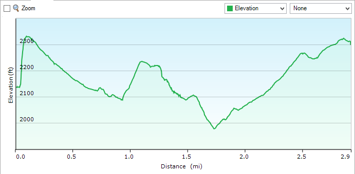
Distance: 2.9 miles
Elevation: 743 feet

This is what the Raven Rock trail looks like pretty much the entire way.

20140928_Coopers_Rock_042

My ankle is displeased with me, because walking on ground like this is a lot more uncomfortable and difficult than you’d think–you have to watch the ground, and even so, smaller rocks slide out from under your feet.

All of which is why we took the McCollum trail back as soon as it branched off.

And the reason it looks like an old road, is because that’s what it is. This is how they got all the equipment for the power lines up the hill. So perhaps this is Mother Nature’s revenge.

Looking east, over the Cheat Canyon.

20140928_Coopers_Rock_036

Looking west:

20140928_Coopers_Rock_039

Looking North. You can see the overlook to the right, and in the background the Longview and Fort Martin power plants.

20140928_Coopers_Rock_001

The power lines and towers kinda ruin the view to the south. (Looking south west here.)

20140928_Coopers_Rock_016

Ferns are quite tenacious.

20140928_Coopers_Rock_018

We were trying to remember where this rock fell from. No place obvious.

20140928_Coopers_Rock_009

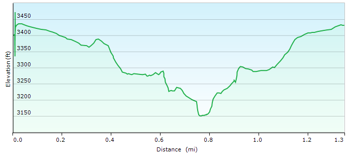
GPS Map of Raven Rock hike

Written by Michelle at 6:00 am    

Comments (0)  Permalink

Categories: Hiking,Photos,State Park / Forest,West Virginia  

Sunday, September 28, 2014

Hiking WV: Blackwater Falls State Park

After discovering the WV Dept of Forestry Fall Foliage Map, WV State Parks Fall Foliage Map, we decided that a trip to Blackwater Falls was in order.

I wanted to visit my favorite overlooks and falls, so we went to lots of different places. (This would have been more energy efficient if we’d had bicycles, however, we only had a couple hours, so we were in and out of the car instead.) The last time we hiked most of these trails, it was early spring and had also been raining for two weeks straight, so there was a LOT of water. This time we were able to hike along creeks that were flooded last time.

It was a gorgeous fall day, temperatures in the upper 60s to 70–perfect for hiking–and the skies were clear. It was a perfect day.

Location: Blackwater Falls State Park
Trails: Pendleton Trace Trail, Dobbin House Trail; Pase Point Trail; Lindy Point Trail
Falls: Elekata Falls (off Elekata Trail); Blackwater Falls
Distance: Pendleton Trace to Dobbins House to Pase Point and Back: 2.9 miles; Lindy Point: .8 mile
Total Distance (including going off trail): 4.9 miles
Elevation: Pendleton Trace to Dobbins House to Pase Point: 261 feet; Lindy Point: 66 feet
Total Elevation (including going off trail): 911 feet

Elekata Falls (here it was in the spring)

20140927_Blackwater_Falls_116

Blackwater Falls (here it was in the spring)

20140927_Blackwater_Falls_013

Oh look! A turkey vulture!

20140927_Blackwater_Falls_025

This sighting was followed by a discussion of the difference between a vulture and a buzzard. Answer: in the US–the terms are interchangeable.

Pendleton Lake

20140927_Blackwater_Falls_095

Wait… what’s that?

20140927_Blackwater_Falls_099

A heron!

20140927_Blackwater_Falls_103

Lindy Point. This is an easy hike for a spectacular view.

20140927_Blackwater_Falls_168

20140927_Blackwater_Falls_162

Pendleton Point

20140927_Blackwater_Falls_032

20140927_Blackwater_Falls_039

Pase Point

20140927_Blackwater_Falls_056

The river below Dobbin House Trail (here’s how things looked in the spring)

20140927_Blackwater_Falls_071

20140927_Blackwater_Falls_191

This area was completely inaccessible in the spring.

20140927_Blackwater_Falls_090

On the Dobbin House Trail someone had set up a silent walk. About a quarter of the signs were botany and nature related, the others were exceedingly touchy-feel. (Look around at the colors. How do they make you feel?) But THIS sign made my day.

Uses of Hemlock

Will no one rid me of the troublesome philosopher?

I am easily amused.

Dobbins House Trail + Pase Point Trail GPS map (with bonus Pendleton overlook and going off trail)

Lindy Point Trail GPS map

Written by Michelle at 10:37 am    

Comments (0)  Permalink

Categories: Hiking,Photos,State Park / Forest,West Virginia  

Sunday, September 21, 2014

Hiking WV: Watoga State Park

Go ahead. Say it: WA-TOGA! WA-TOGA! WA-TOGA!

You’re welcome.

Location: Watoga State Park
Trails: Honeybee Trail, Buckhorn Trail, Dragon Draft Trail
Distance: 2.4 miles
Elevation: 920 feet

At Watoga there’s a lake:

20140920_Watoga_005

As you can see, the leaves are just starting to change:

20140920_Watoga_014

There’s also an arboretum:

20140920_Watoga_019

This is a tree (still alive) that has been attacked by some kind of insect, which was then rooted out by woodpeckers.

20140920_Watoga_023

We hiked the outside of the trail, then cut into the center, where the arboretum trail crosses back and forth across the creek:

20140920_Watoga_020

It’s fascinating, the amount of stone and rock in the creek bed, that has been uncovered over time, and shifted around every time there’s a hard rain.

There’s also access to the Greenbrier river:

20140920_Watoga_025

20140920_Watoga_040

20140920_Watoga_047

It was a lovely park, and as it’s the end of the season, it was quite empty and quiet (which I always enjoy).

GPS map of hike

Written by Michelle at 11:54 am    

Comments (0)  Permalink

Categories: Hiking,Photos,State Park / Forest,West Virginia  

Sunday, August 31, 2014

Hiking WV: Holly River State Park

Due to events beyond our control, we arrived at the park much later than expected. That, combined with the heat, meant we only took a partial hike along the Left Fork of the Holly River.

It was utterly gorgeous, and I very much want to go back and hike the Potato Ridge trail complete, as well as other trails in the park.

The park office provides maps with distances as well as an elevation graph.

Location: Holly River State Park
Trail: Potato Ridge Trail (partial)
River: Left Fork Holly River
Distance: 3.6 miles (we only hiked 1.7 miles)
Ascent:

This trail is NOT going to be accessible after a rain or when the river is running high. Not unless you want to get your feet wet.

20140830_Holly_River_021

The Potato Ridge trail abuts private property, so local residents will ride their 4-wheelers off park territory to visit the river. When we got to Shupe’s Chute, there was a father with his young son (probably about 4) sitting on the rocks watching the water. When we arrive, the son excitedly told us that the water was VERY fast, and picked up leaves to throw into the water.

It was, in fact, very fast.

20140830_Holly_River_005

Shupe’s Chute was pretty fascinating. I’ve tried to stitch together three pictures so you can see it in its entirety, but I don’t think it worked really well.

shupes_chute

Then when we mentioned we were going to hike down to the lower falls, he begged his dad to go down to the lower falls too. When we passed them later (them heading back, us heading down) the boy excitedly told us that if we crossed the river, we could even go UNDER the falls.

He was delightful.

20140830_Holly_River_028

20140830_Holly_River_032

20140830_Holly_River_035

Written by Michelle at 10:53 am    

Comments (0)  Permalink

Categories: Hiking,Photos,State Park / Forest,West Virginia  

Saturday, August 16, 2014

Hiking WV: Audra State Park

Cooler weather and an influx of horrific traffic to Morgantown got us on the road again, this time to Audra State Park.

The Girst Mill (it’s earlier use) is long gone, except for a grinding stone, but the Alum Cave trail along the river has multiple paths to wander down to the water, where you can swim and sunbathe in relative isolation if you’re willing to hike a bit.

I really like Audra. It’s not a particularly strenuous hike (we went out and back the same way, because I prefer to walk closer to the water) but it’s very pretty, and has lots of options for going down to the water.

Location: Audra State Park
Trail: Alum Cave Trail
River: Middle Fork River
Distance: 2.9 miles
Ascent: 497 feet

I love the board walk. It’s more solid than it looks.

20140816_Audra-State-Park_043

20140816_Audra-State-Park_046

20140816_Audra-State-Park_016

We had a long discussion about this root formation:

20140816_Audra-State-Park_039

Rotting logs can be absolutely fascinating:

20140816_Audra-State-Park_027

And lots of paths to get down to the water:

20140816_Audra-State-Park_030

20140816_Audra-State-Park_035

GPS map of hike

Written by Michelle at 9:01 pm    

Comments (2)  Permalink

Categories: Hiking,Metal Chickens,Photos,State Park / Forest,West Virginia  

Monday, July 14, 2014

Hiking WV: Cedar Creek State Park

Location: Cedar Creek State Park
Trail: Stone Trough Trail
Distance: 3.0 miles
Elevation: 814 feet

The trail was slightly problematic at two parts. At the sealed oil well pipe, when coming up from the stone trough, it took us a long time to pick the trail back up. (You head right, and then head back up the hill.) And towards the end of the trail (for us) the trail suddenly went down a very steep hill. The rest of the trail was relatively easy, but this part was not.

This is not the sealed gas/oil head. This was a random, rusting piece of machinery.

20140712_Cedar_Creek_009

20140712_Cedar_Creek_008

20140712_Cedar_Creek_003

20140712_Cedar_Creek_011

20140712_Cedar_Creek_015

20140712_Cedar_Creek_022

“Yes, you’re really going that way.”

20140712_Cedar_Creek_032

That was moderately steep.

20140712_Cedar_Creek_034

Yeah, a bit steep here.

20140712_Cedar_Creek_036

“We’re not kidding. You go pretty much straight up here.”

20140712_Cedar_Creek_037

GPS map of the trail.

Written by Michelle at 6:00 am    

Comments (0)  Permalink

Categories: Hiking,Photos,State Park / Forest,West Virginia  
« Previous PageNext Page »

Powered by WordPress