Random (but not really)

Sunday, October 5, 2014

Hiking West Virginia: Cranberry Glades & the Falls of Hills Creek

Well, it was more casual strolling than hiking, but both of these are places you shouldn’t miss. Although it was only the 4th of October, it was 42 degrees at Cranberry Glades Botanical Area, and there were a few snow flurries. So the weather there can be quite different from the weather elsewhere.

Which means I was wishing that I had worn much warmer pants.

Location: Falls of Hills Creek and Cranberry Glades Botanical Area
Trails: Cranberry Glades Botanical Area & the Falls of Hills Creek
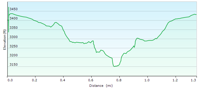
Distance: Cranberry Glades Botanical Area: 0.6 mile; Falls of Hills Creek: 1.3 miles
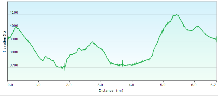
Elevation: Falls of Hills Creek: 367 feet

Cranberry Glades Botanical Area

20141004_Cranberry_Glades_001

The Cranberry Glades Botanical Area is a flat boardwalk, so it is accessible to everyone. Although it is only a 0.6 mile loop, there is incredible biological diversity in that small area.

20141004_Cranberry_Glades_002

20141004_Cranberry_Glades_006

20141004_Cranberry_Glades_009

20141004_Cranberry_Glades_014

20141004_Cranberry_Glades_019

Yup. Snow.

20141004_Cranberry_Glades_028

Cranberry Wilderness Area

This area was in an area not in the boardwalk, but similar botanically, and the light was a lot better.

20141004_Cranberry_Wilderness_Area_063

20141004_Cranberry_Wilderness_Area_039

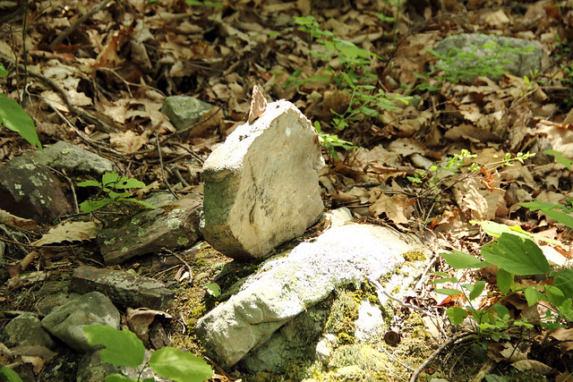
The Falls of Hills Creek

The upper falls are accessibly by a gently sloping path. They were also kinda boring without much water going through the area.

The rest of the path was a lot of stairs. But utterly worth the hike.

20141004_Falls_of_Hills_Creek_005

The Middle Falls

20141004_Falls_of_Hills_Creek_011

The Lower Falls

20141004_Falls_of_Hills_Creek_017

The stairs are quite steep in places.

20141004_Falls_of_Hills_Creek_026

Cranberry Glades Botanical Area GPS map
Falls of Hills Creek GPS map

Written by Michelle at 10:12 am    

Comments (0)  Permalink

Categories: Hiking,National Park / Forest,Photos,West Virginia  

Saturday, May 24, 2014

Hiking West Virginia: Seneca Rocks

Friday we hiked up Seneca Rocks, in memory of my cousin Ben.

We hiked to the top without stopping, because that’s what Ben would have done. One the way down, however, I stopped many times for pictures.

Location: Seneca Rocks
Distance:4.4 miles
Elevation: 1092 feet

20140523_Seneca Rocks_083

20140523_Seneca Rocks_087

20140523_Seneca Rocks_056

Most of the above pictures were taken from the viewing platform (noted with red arrow below), or several feet above. Because of COURSE I went past the STOP HERE DO NOT GO FURTHER sign.

Seneca_Rocks_Viewing_Platform

The hike started approximately from where the next two pictures were taken, and then went up to the viewing platform (and just past).

Seneca Rocks at sunset:

20140522_Seneca Rocks_018

Seneca Rocks mid-day:

20140523_Seneca Rocks_167

20140523_Seneca Rocks_109

20140523_Seneca Rocks_128

20140523_Seneca Rocks_074

20140523_Seneca Rocks_076

Seneca Rocks Hike (gps map)

Written by Michelle at 8:00 pm    

Comments (0)  Permalink

Categories: Hiking,National Park / Forest,Photos,West Virginia  

West Virginia Ramblings: Dolly Sods

As I said, pretty much as soon as we get back to the car, the sun came out, and the day was beautiful from there on out.

And from these pictures, you can see why we wanted to hike Dolly Sods in the first place.

20140522_Dolly_Sods_060

20140522_Dolly_Sods_014

20140522_Dolly_Sods_013

20140522_Dolly_Sods_035

20140522_Dolly_Sods_063

Written by Michelle at 10:11 am    

Comments (0)  Permalink

Categories: National Park / Forest,Photos,West Virginia  

Hiking West Virginia: Dolly Sods

We took Thursday and Friday off, and traveled south. Thursday, we hiked Dolly Sods, which ended up being far less pleasant that it sounds, because 1) it rained for about 3/4 of the hike 2) it’s been raining for most of May and 3) about 2/3 of the way through our hike, the trail went through a swamp. And it’s been raining a lot.

Location: Dolly Sods National Wilderness Area
Trails: Blackbird Knob Trail, Upper Red Creek Trail, Dobbin Grade Trail (swamp), Beaver Dam Trail, and then Forest Road 75 back to the Blackbird Knob Trailhead)
Distance: 6.7 miles
Elevation: 838 feet

Here is what part of the non-swamp portion of the trail–the Upper Red Creek Trail–looked like:

20140522_Dolly_Sods_008

Here’s another view of the Upper Red Creek Trail area. Yes, it was raining. And raining. And raining.

20140522_Dolly_Sods_005

This is part of the Blackbird Trail, and approximately where we made the mistake of turning onto the Upper Red Creek Trail. Which would eventually lead us into the swamp.

I admit that even in the rain the Blackbird Trail was beautiful.

20140522_Dolly_Sods_004

20140522_Dolly_Sods_003

Here are the remains of the swamp I took out with me.

20140523_Muddy_003

Dolly Sods Trails Hike (gps map)

After we finished our hike? The rain stopped, the skies cleared, and it was beautiful.

Written by Michelle at 9:47 am    

Comments (0)  Permalink

Categories: Hiking,National Park / Forest,Photos,West Virginia  
« Previous Page

Powered by WordPress